Publié le 23 juin 2022
In building this capacity, organizations need a modular platform which allows them to streamline data acquisition campaigns, image processing and online hosting of both the raw data and derived information products. Discover more about MAPEO, a platform tailored to the operational scenarios of the customer to guarantee that the complexity of their use-cases is addressed adequately.
Digital transformation of society and the digital twin
Meeting with policy officers responsible for operational resource management in various domains, I often hear the same feedback, similar struggles and corresponding requests. Where they used to work with advice, reports and estimations, they now want to base their decisions on data and facts. And the requests can be diverse. From drone-based corridor mapping to enforce environmental policies over establishing a continuously updated spatial database of doorbell counts via mobile mapping to monitor migration patterns in a city.
Reynvoet Hilde, Director of Housing at the City of Ghent
Local management of resources (land, water, infrastructure, materials, and energy) and situations (change, security, mobility, social patterns) is expected to be data driven, since we now have the technological capacity to continuously monitor, measure and handle massive amounts of data. This is currently being framed as “digital twin” technology. It is a natural consequence of the emergence of cloud computing, web services, sensor networks and social networks from around 2005 onwards. We clearly entered an era of digital transformation where remote sensing as intelligence source has become more relevant than ever before!
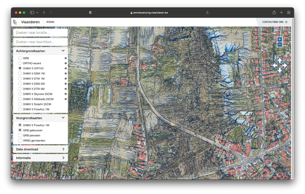
LiDAR (16 points/m²) and orthophoto (20cm resolution) based Digital Twin of Flanders for environmental and civil infrastructure resource management and enforcement applications. The example here shows the LiDAR derived overland flow patterns as part of an integrated water resources management.
Intelligence information at the right temporal and spatial resolution
Data resolution – both in space and time – is key for the useability of the information services of our networked society. For many decades airborne and terrestrial remote sensing was and still is the default intelligence source for local governments and companies because of the supreme data quality for visual or computer aided quantitative information gathering. Nowadays, thanks to the advent of small drone systems, remote sensing has become a measurement technique for everyone. The relevance of small drones is rooted in neither unique missions nor economy, but rather in the operational impact of simple logistics. In an operational sense, they are direct support assets for the unit employing them and enable to gather data at the spatial and temporal resolution their applications require.
Read the rest of the article
on VITO Remote Sensing's website