Publié le 18 juin 2021
High-quality satellite-based ocean colour products can provide valuable support and insights in management and monitoring of coastal ecosystems. Today’s availability of Earth Observation (EO) data is unprecedented including traditional medium resolution ocean colour systems e.g. (Sentinel-3/OLCI), high resolution land sensors (e.g. Sentinel-2/MSI) and geostationary satellites (e.g. SEVIRI). Each of these sensors offers specific advantages in terms of spatial, temporal, or spectral characteristics. With the availability of such diverse ocean colour products, the question arises on how to optimally integrate them to support marine monitoring applications.
The STEREO Multi-sync exploration project brought together researchers from the Royal Belgian Institute of Natural Sciences (RBINS) and the GeoHydrodynamics & Environment Research group of the University of Liege.
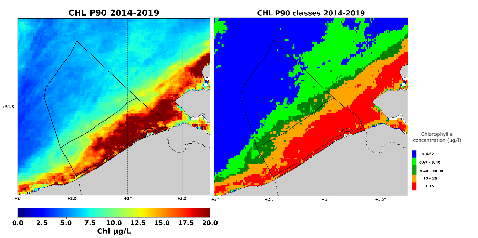
(Left) The multi-temporal 90-percentile product of the chlorophyll-a concentration (CHL-P90) for the growing season March-October during the period 2014-2019 based on satellite observations in the Belgian Coastal Zone. (Right) Classification of the CHL-P90 as an eutrophication indicator with the red class CHL-P90> 15µg L-1 indicating the eutrophied region.
This team of sea enthusiasts has developed advanced ocean colour products (i.e. suspended particulate matter and chlorophyll a concentration) through the optimization of satellite-based ocean colour products and the synergetic use of multi-scale EO data taking advantage of
- spectral characteristics of Sentinel-3 (S3),
- the high spatial resolution of Sentinel-2 (S2) sensors and
- the high temporal resolution of SEVIRI.
A key element in this approach is the Data Interpolating Empirical Orthogonal Functions (DINEOF) technique developed to reconstruct missing data (see our STEREO Toolbox page / EOF-based Time Series Reconstructor).
Find all the results generated by Muli-Sync on the project website, also accessible via the project sheet on our website.
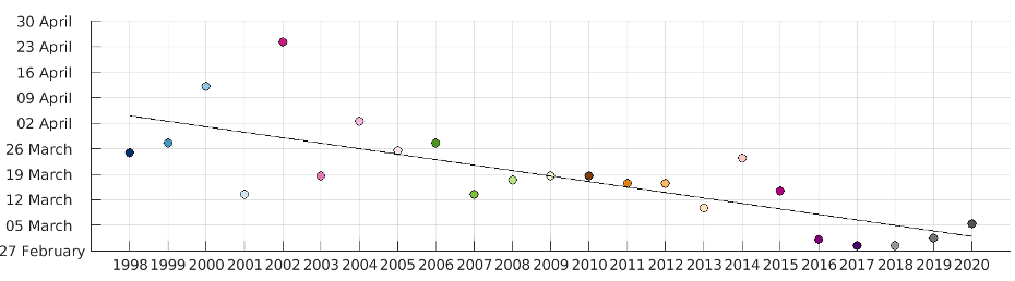
Date at which the CHL concentration reaches the annual median value for the first time each year. The solid black line shows a linear fit to the dates, with r=0.75
More information
The Multi-Sync project (RBINS website Directorate Natural Environment)
Eutrophication monitoring of Belgian coastal waters with MULTI-SYNC