Publié le 17 novembre 2022
Later this month, it will be presented to more than 15,000 artificial intelligence researchers at the 36th Conference on Neural Information Processing Systems (NeurIPS 2022).
WorldStrat – which draws on imagery from both privately-owned and institutional missions – enables worldwide analyses and promotes the development of machine learning methods, such as techniques to enhance the resolution of images.
It has already been downloaded by users more than 3000 times, since its launch in June.
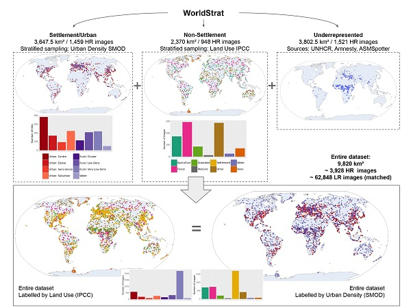
The dataset covers every type of location, urban density, and land use, making it suitable for countless applications, including disaster response, natural resource management and urban planning.
Work on WorldStrat began in 2021, as part of a project backed by ESA.
Julien Cornebise, Honorary Associate Professor at University College London and project lead, says, “The combination of high-resolution commercial imagery and machine learning has huge potential to enable planetwide analyses, which could help to tackle all kinds of global challenges – the problem is that commercial data are often locked behind a paywall.
“ESA’s TPM programme made our project possible by providing free access to data that would normally be very expensive.”
As part of the project, Cornebise and his colleagues drew on data delivered by the Airbus SPOT 6 and SPOT 7 missions, which were added to the TPM programme in 2012 and 2014, respectively. These satellites can provide imagery with resolutions as high as 1.5 m.
Around 4000 highly detailed SPOT images were used, covering some 10,000 square km of Earth’s surface.
In contrast to their high spatial resolution, these data often have a relatively low temporal resolution, as they are typically intended for specific commercial applications, rather than longer-term analyses.
To address this issue, freely available Copernicus Sentinel-2 data were used. These images are less detailed than SPOT images, but they are collected at regular time points.
Source:
European Space Agency. (n.d.). New worldwide dataset captures the planet in fine detail. https://earth.esa.int/eogateway/news/new-worldwide-dataset-captures-the…