Satellite characteristics
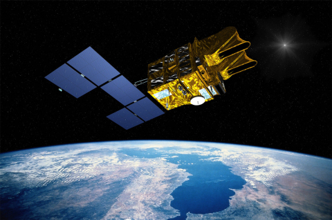
Launch Date - End 4 May 2002 - 31 March 2015
Status Decommissioned
Orbit type Sun-synchronous circular orbit
Altitude 822
Orbit inclination 98.7
Equatorial crossing time 10:30:00
Orbit period 101.4
Satellite family: SPOT (Système Pour l'Observation de la Terre)
The SPOT Earth observation system was conceived and designed by CNES (Centre National d'Etudes Spatiales), the French space agency, and developed in association with the Belgian Science Policy Office (formely Federal Office for Scientific, Technical, and Cultural Affairs) and the Swedish National Space Board (SNSB).
More information:
SPOT 6 & 7 Technical Sheet (Airbus DS)
SPOT Programme (CNES)
Sensor characteristics
| Sensor name | HRG (High Resolution Geometric) |
|---|---|
| Sensor short description | |
| Sensor type | Imaging radiometer (Vis/IR) |
| Resolution class | Very High (1 - 5 m) |
| Spatial resolution | 5<br>10 |
| Swath width (at nadir) | 60 km |
| Revisit frequency | 3 dagen |
| Max look angle | 31 ° |
| Sensor name | HRS (High Resolution Stereoscopic) |
|---|---|
| Sensor short description | |
| Sensor type | Imaging radiometer (Vis/IR) |
| Resolution class | High (5 - 30 m) |
| Swath width (at nadir) | 120 km |
| Revisit frequency | 3 dagen |
| Max look angle | 20 ° |
| Sensor name | VEGETATION (Vegetation Monitoring Instrument) |
|---|---|
| Sensor short description | The VEGETATION programme was co-financed by the European Union, Belgium, France, Italy, and Sweden and being conducted under the supervision of the CNES (National Centre for Space Studies, France). The aim of the VEGETATION instrument is to provide accurate measurements of the main characteristics of the Earth’s plant cover. Practically daily global coverage and a resolution of 1 km make this sensor an ideal tool for observing long-term regional and global environmental changes. Several products are available, including daily and ten-day synthesis products (at full resolution as well as 4km and 8km reduced resolutions) for the geographical areas that the user has defined as well as for complete global coverage. The SPOT VGT images are processed, archived and distributed for free by the CvB Product distribution portal. |
| Sensor type | Imaging radiometer (Vis/IR) |
| Resolution class | Very Low (> 1 km) |
| Spatial resolution | 1165m |
| Spectral bandwidth | B0: 0,43 - 0,47µm (blue) - Oceanographic applications/ Atmospheric corrections<br> B2: 0,61 - 0,68 µm (red) - Vegetation photosynthesis activity<br> B3: 0,79 - 0,89 µm (near IR)<br> MIR: 1,58 - 1,75 µm (middle IR) - Ground and vegetation humidity |
| Swath width (at nadir) | 2250 km |
| Revisit frequency | 1 dagen |
