Context and objectives
![]()
![]()
The region of interest, covering the Virunga Volcanic Province (VVP) in eastern DRC, western Rwanda and Burundi, and southwest Uganda, which is one of the most densely populated of Africa, is threatened by a combination of seismic, volcanic and landslide geohazards. Active volcanoes (Nyiragongo and Nyamulagira) occasionally provoke catastrophic disasters as in 1977 and 2002 when the Nyiragongo eruptions caused major destructions in the city of Goma. The region is also prone to earthquakes. In 2008 a magnitude 6.2 earthquake hit the Kivu area, causing important damages and casualties in DRC and Rwanda. Landslides, including a wide range of ground movements, are possibly the most important geohazard in terms of recurring impact on the populations, causing fatalities every year and resulting in structural and functional damage to infrastructure and private properties.
RESIST aimed at contributing to the characterization and comprehension of the mechanisms leading to volcanic eruption and landslide triggering, as well the detection of their precursory signals.
Project outcome
Scientific results
RESIST improved the knowledge on the system of the Nyiragongo and Nyamulagira volcanoes and on the landslides in the region. The key-achievements are:
- the development of the telemetered seismic network (18 stations)
- the development of the telemetered GNSS network (17 stations)
- the development of the telemetered Infrasound network (3 arrays)
- the development of Kivu rain gauge network (12 stations)
- the automation of the data processing (GNSS, InSAR, Seismic, Infrasound…)
- the improvement of CSL interferometric suite (CIS)
- the improvement of InSAR MSBAS
- the development of the SAR cast shadow method
- the development of SO2 fluxes algorithms
- the creation of the first systematic landslide inventory for that region
- the understanding of major environmental parameters causing landslides
- a derived geomorphologicalconsistent susceptibility model
- the validation of TRMMderived products to characterize rainfall in a tropical mountain region
- the demonstration of the complementarity between the spaceborne and ground based techniques used.
The link between seismicity and the SO2 flux of the two active volcanoes was investigated and interpreted for signs of volcanic unrest. The developed methodology allowed to discriminate between magma migration in and out of Nyamulagira’s vents.
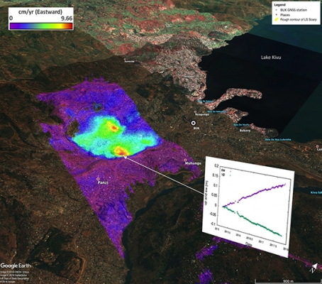
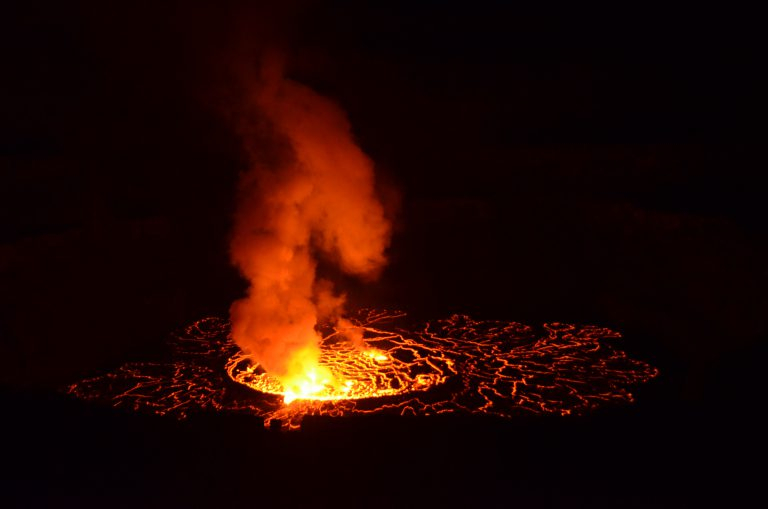
Nyiragongo lava lake activity and fluctuations were studied. The volcano was shown to have a nearly constant background seismic tremor source and low SO2 degassing associated with the dynamics of its lava lake. The low-frequency seismo-acoustic records can be used to track fluctuations of the lava lake level on a daily basis. New seismic evidence supports the effect of major pressure changes in the plumbing system upon large and sudden drops of the lake level associated with excess degassing.
The progressive rise of the Nyiragongo lava lake also corresponds to a regional inflation, suggesting the refill at depth of the Nyamulagira magmatic source. For the first time, evidence was found pointing to a possible link between activity at Nyiragongo and Nyamulagira.
RESIST investigated whether eruptive deformations occurred for each eruption and what were the mechanisms behind it.
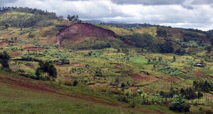
The project catalogued ~10000 landslide occurrences of various types and age for the first time. Most recent landslides are shown to be linked to rainfall, respond to seasonal climatic variability and can sometimes be triggered in a few hours. Their occurrence is also linked to human activities while few seismic-triggered landslides are reported. The relation between instability triggers and slope failure is not straightforward; but is influenced by lithology and weathering.
New geomorphological-consistent susceptibility models were produced that perform twice better in terms of predictive power than the available global/continental products. These showed lower rainfall thresholds in places that are naturally more susceptible to landsliding. The susceptibility analyses also highlighted the importance of vegetation cover changes as well as the tectono-morphologic context.
Societal (including environmental) relevance
Even though the main focus of RESIST project was on fundamental research, conducting research on natural hazards in developing countries cannot be envisaged without a close collaboration and knowledge sharing with the local research community and local authorities. The local partners were trained to allow them to benefit from the project and to sustain the developed infrastructures. In addition to continuous training during field visits and in distance e-mode, 4 dedicated training sessions were organized locally (funded by external resources):
The local authorities have been constantly kept aware of the field operations and the research results.
Potential users
- The most important user of the results in volcano monitoring is the Goma Volcano Observatory;
- Contributors/partners in the Kivu seismic and geodetic networks:
- Local authorities and provincial/national governments who have access to a high level of data quality on major geohazards that are affecting their region;
- Processing tools and techniques developed within the project such as the CSL, MSBAS InSAR tools were installed at the RMCA, the Belgian Geological Survey, the University of Luxembourg, and the University of Rio Negro (Argentina).
Outreach
RESIST: Tracking the rainfalls that trigger landslides in Central Africa
RESIST: Traquer les précipitations pour prévenir les glissements de terrain
RESIST: In het spoor van de regens die in Centraal-Afrika aardverschuivingen in gang zetten
| Project leader(s): | MRAC/KMMA - Natural hazards and cartography | |||||
| Belgian partner(s) |
|
|||||
| International partner(s) |
|
|||||
| Location: |
Continent:
Country:
Region:
|
|||||
| Related presentations: | ||||||
| Website: | http://resist.africamuseum.be | |||||