Published on 23 February 2021
The fertile land at the foot of volcanoes has always attracted people despite the dangers of eruption. In 2015, it was estimated that more than 1 billion people lived within a 100 km radius of an active volcano and therefore potentially exposed to volcanic risk. Nearly 60 million people are believed to be living within a potential evacuation radius (10 km).
To protect these populations, it is crucial to succeed in modeling volcanoes and detecting possible warning signs as early as possible in order to anticipate destructive events and take all the necessary preventive measures.
Deformations under surveillance
This implies having very precise measurements of the topographical changes resulting from ground displacement. The challenge for researchers is: how to obtain locally continuous and confident measurements in such a steep topography?
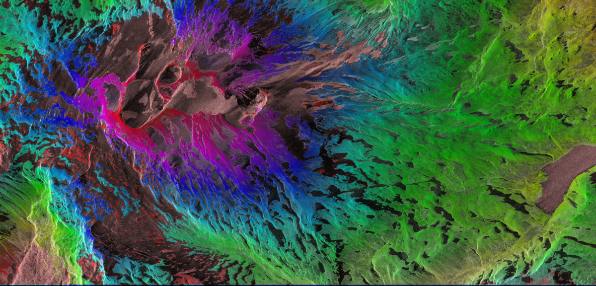
Interferometric phase computed from a pair of acquisitions over the Copahue volcano (15- 26/12/2014)
Synthetic Aperture Radar interferometry (InSAR) obtained from satellite data has long been used for topographic or relative displacement measurements, but obtaining continuous measurements over the entire scene is still a challenge.
General principle of InSARThe radar satellite image provides two pieces of information for each pixel: amplitude and phase. The amplitude characterizes the reflectivity of the imaged surface and the phase characterizes the vibrational state of the wave upon its return to the sensor, a state which depends in part on the round trip time of the wave. When a target is observed twice, over a short period of time, it is possible to determine a possible relative displacement of the target by evaluating the phase difference between the two images acquired under similar conditions. |
Splitting bands to see better
As part of, among others, former STEREO project Vi-X, the Liège Space Center (CSL) has developed a new technique that has proven to be powerful for performing absolute height and displacement measurements. This technique, called Split Band Interferometry (SBInSAR), allows to obtain more precise results thanks to a process of sub-banding of the (usually fairly large) spectral band of SAR satellite sensors. This process, also called Multi Chromatic Analysis (MCA), is equivalent to performing a spectral analysis of SAR images.
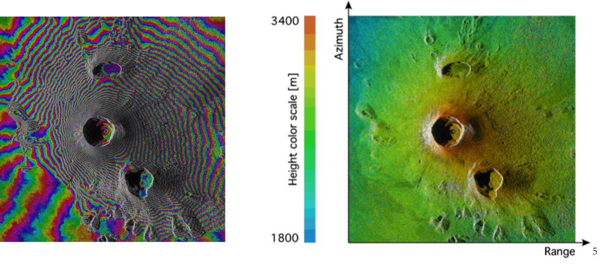
Interferogram and “Split-Band” phase on the Nyiragongo volcano (TanDEM-X data 07/21/2012): zoom on the crater.
From Goma to the Andes Cordillera
The objective of the STEREO III project MUZUBI was to evaluate and quantify the advantages, limitations and applicability of the method for available SAR sensors. To answer this, the team, made up of researchers from the CSL, the Royal Museum for Central Africa (MRAC) and the National Museum of Natural History of Luxembourg and the European Center for Geodynamics and Seismology (MNHN/ECGS) had the idea to apply the technique to two active volcanic areas: the area of the Nyiragongo and Nyamulagira volcanoes in the Democratic Republic of Congo and the Copahue volcano located in the Andes Cordillera on the border between Argentina and Chile. The method was adapted to specific data from the German constellation of twin satellites TanDEM-X.
To that effect they carried out a detailed study of the limits of the method, comparing different sensors with different frequency bandwidths and acquisition modes (Sentinel-1, Cosmo-SkyMed, TerraSAR-X and Tandem-X), and different types of targets (the city of Cologne, the Uluru monolith in Australia, the Nyamulagira and Copahue volcanoes and the Virunga region).
Encouraging results
The results obtained made it possible to demonstrate the added value of the SBInSAR technique when it is combined with classical techniques to retreive measurements of absolute height and ground displacements. More specifically, these results highlighted the power of the method for the expected successor to TANDEM-X, the High Resolution Wide Swath (HRWS) SAR system.
Crater and lava lake
Simultaneously, researchers from the MRAC and ECGS used other methods (SAR shadowing, UAV photogrammetry and Multidimensional Small Baseline Subset - MSBAS) that were initiated within the framework of STEREO project RESIST to assess and measure changes in the level of the lava lake and morphological changes in the crater of the Nyiragongo volcano, including the rapid rise of its bottom.

Ground deformation measured with MSBAS method [Samsonov and Oreye 2012; 2017] for a pixel located at the bottom of the Nyiragongo's crater (Radarsat data). Background map: Line of Sight velocity wrapped on SAR amplitude.
More information
STEREO project MUZUBI (MUlti Zone phase Unwrapping using advanced Split Band Interferometry)
STEREO project RESIST (REmote Sensing and In Situ detection and Tracking of geohazards)
STEREO project Vi-X (Study and monitoring of Virunga volcanoes using Tandem-X)