Published on 17 March 2023
Since 2006, the Belgian Science Policy’s STEREO Programme has funded several research projects aimed at studying active volcanoes and assess the associated hazards using remote sensing techniques. The VERSUS spin-off project (STEREO-III Programme, 2019-2022) has capitalized on this heritage by developing advanced techniques that use new generations of satellites and sensors to study active volcanoes with rare and fascinating features: lava lakes.
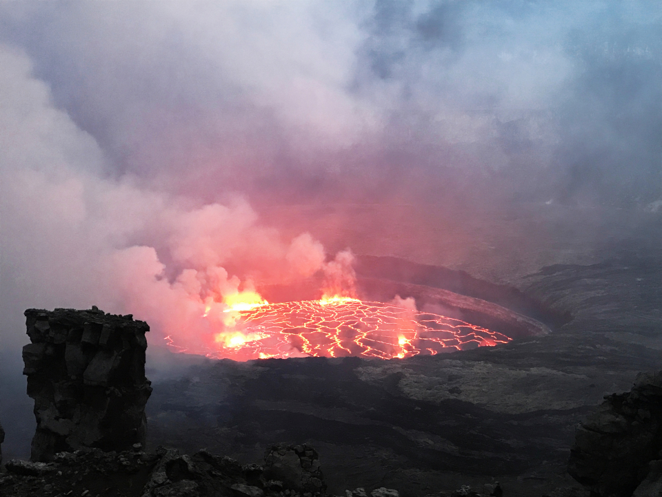
Photo of the Nyiragongo lava lake (photo © B. Smets)
A lava lake is a basin of lava connected through an open conduit to a magmatic reservoir in the earth's crust. The lava remains molten thanks to gas- and heat-controlled convection movements. When lava lakes persist for years or decades, such as those at the Nyiragongo (Eastern D.R. Congo) and Kīlauea (Hawaii, USA) volcanoes, their dynamics may reflect pressure changes in the volcanic plumbing system. This allows us to get valuable insights in the magmatic and volcanic processes that control the eruptive activity.
In the VERSUS project, researchers from the Royal Museum for Central Africa, the Royal Belgian Institute for Space Aeronomy, the European Centre for Geodynamics and Seismology (Luxembourg), and the U.S. Geological Survey studied the Nyiragongo and Kīlauea volcanoes using satellite remote sensing and ground-based measurements. The goal was to better understand the lava lake level variations and relate them to hazardous flank eruptions. The results of the project showed that substantial drops in the level of lava lakes—sometimes by tens of metres—can be linked to underground magma movements. This teaches us that, even though lava lakes can help release pressure in a volcano by allowing gas to escape from the system, intrusions can still occur in the crust.
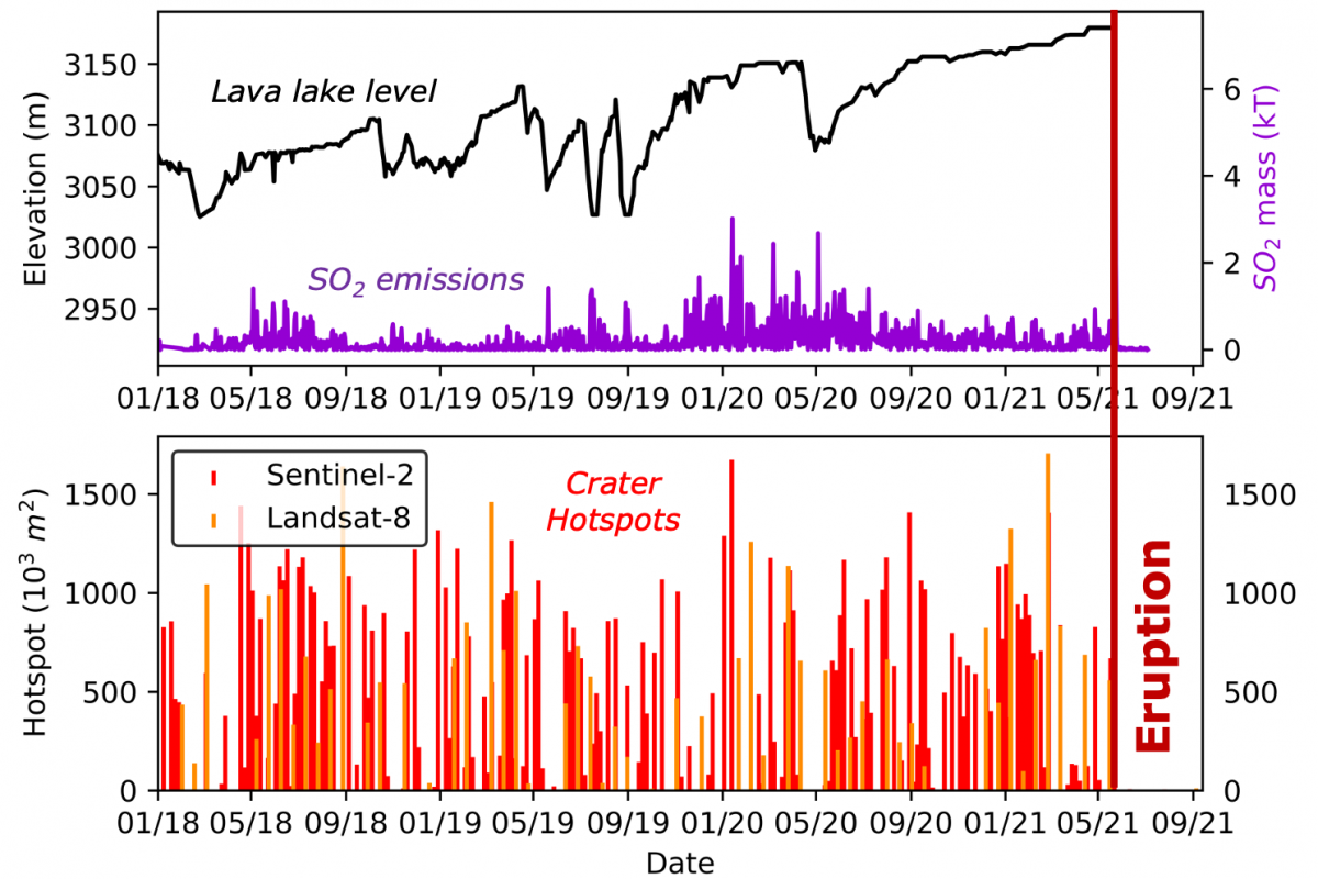
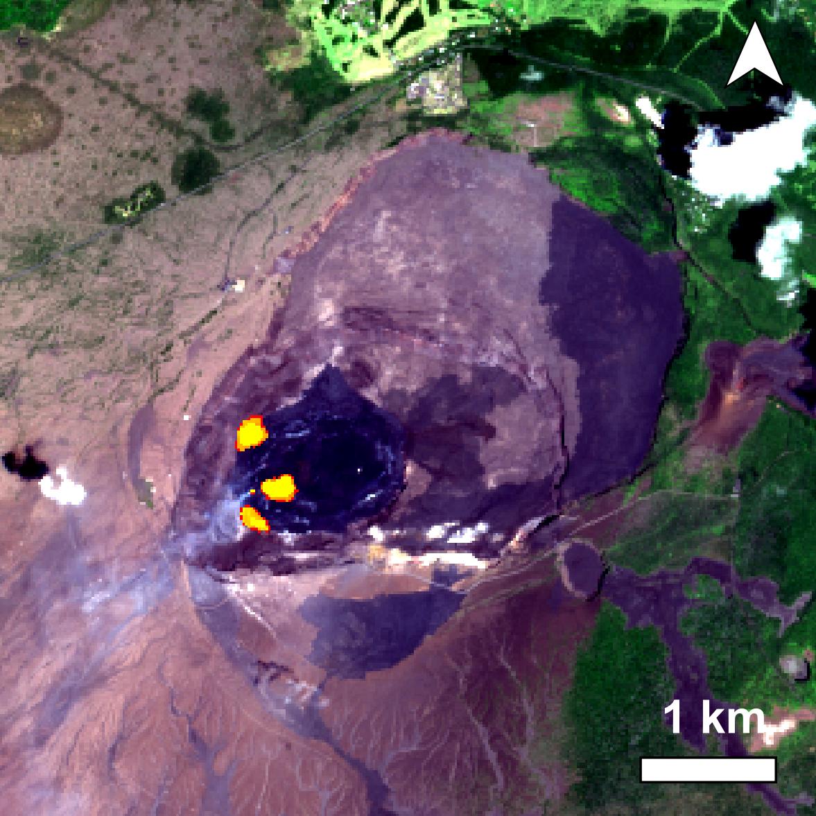
Lava lake level, SO2 emissions and hotspot detection time-series over Nyiragongo volcano, produced using satellite remote sensing. The plots show the impact of the 2021 flank eruption
On 22 May 2021, Nyiragongo erupted without any warning, producing deadly lava flows that caused widespread destruction in the city of Goma (~1 million inhabitants). The flank eruption was followed by a seismic crisis caused by very shallow magma movements (<500m) beneath Goma and Lake Kivu.
The VERSUS project analysed this eruption in detail and the results were published in Nature (Smittarello et al., 2022 – open-access). The study shows that the combination of magma storage close to the surface and persistent lava lake activity poses a challenge to volcano monitoring, as flank eruptions may occur with only very short-term (i.e. minutes) warnings. The shallow magmatic intrusion that followed the 22 May 2021 eruption of Nyiragongo also raises concerns about the possibility of even more hazardous scenarios, such as lava flowing into densely urbanised areas or explosive interactions with the gas-rich Lake Kivu (a so-called phreato-magmatic or limnic eruption).
|
Phreatomagmatic eruptions are volcanic eruptions resulting from the interaction between magma and water. They are driven by thermal contraction (as opposed to magmatic eruptions, which are driven by thermal expansion) of magma when it comes in contact with water. Limnic eruptions are a very rare type of natural disaster in which dissolved CO2 suddenly erupts from deep lake waters, forming a gas cloud capable of suffocating wildlife, livestock, and humans. A limnic eruption may also cause tsunami or seiche as the rising CO2 displaces water. |
More generally, the VERSUS project highlighted the need to further study lava lakes, as they provide key information on magmatic and volcanic processes, which help us better understand and monitor active and hazardous volcanoes.
Researchers in the VERSUS project:
Royal Museum for Central Africa / Vrije Universiteit Brussel
benoit.smets@africamuseum.be

European Centre for Geodynamics and Seismology / National Museum of Natural History (Luxembourg)
ndo@ecgs.lu
More information:
- STEREO project VERSUS (Open-Vent Volcano Remote Sensing Monitoring Using Spaceborne Imagery)
- Mother project RESIST (Remote Sensing and In Situ detection and Tracking of geohazards)
- Related webstories: