This travelling exhibition has been realized jointly by the Belgian Science Policy Office, the Earth and Life Institute from the Université catholique de Louvain and the Flemish Institute for Technological Research (VITO) on the occasion of the International Year of Forests 2011. It aims to show how satellite images can help to better manage and preserve the forests of our planet.
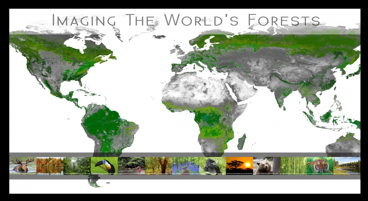
Map of the world’s forests
The global image is a forest classification derived from SPOT VEGETATION images recorded over 10 years (2000 – 2010). This classification is one of the results of a study financed by the Science Policy with the objective to characterize, quantify and foresee the vegetation dynamics at global scale based on long term time series of satellite images. This study has been done in the context of the REDD programme (reducing emissions from deforestation and forest degradation). Seven important forest types can be distinguished.
Forests in the world
Forests cover more than 4 billion hectares, ie nearly a third of the landmass of the planet. 300 million people live in forests but more than a quarter of the world population, 1.6 billion people, depend on forest resources for their livelihoods.
|
What's a forest? Primary forests are forest of native species, where there are no clearly visible indications of human activities and the ecological processes are not significantly disturbed. |
Human interest
More than half the world's forests are destined primarily for production of wood and non wood forest products. In addition to logging for industrial purposes (construction, pulp and paper ...), forests are essential to the survival of many poor people by supplying them with firewood, but also food (fruits, honey, berries, mushrooms, game ...), feedstocks, medicinal plants, resins ...
Ecological interest
Forests have not only an economic and social function, their ecological role is fundamental. Forests provide a habitat for different plants, animals and microorganisms. In that capacity they are the most important source of biodiversity in the world as they harbour 80% of terrestrial species.
Environmental interest
Forests play a crucial regulating role in the Earth’s climate. Forest ecosystems (including biomass, dead wood and soil) "capture" over 650 billion tons of carbon, more than the total of all carbon in the atmosphere.
Likewise, forests prevent erosion and reduce the effects of extreme events (avalanches, floods ...). Indeed, the different layers that make up the forest preserve and stabilize soils and reduce runoff. Fluctuations in river water levels are reduced and water, filtered by forest soil, can be used as surface water of good quality.
Forests repartition
| Forests area in 2010 (1000 ha ) | % of the world's forests | % of total land area | % of forest area reported to be primary forest | Countries with the largest forest area 2000-2010 (1000 ha) | Annual forest change 2000-2010 (1000 ha) |
Annual forest change 1990-2000 (1000 ha) |
|
|---|---|---|---|---|---|---|---|
| Africa | 674 419 | 16 | 23 | 10 | Democratic Republic of the Congo, Sudan | - 3 414 | - 4 067 |
| Asia | 592 512 | 14 | 19 | 19 | China, Indonesia | + 2 235 | -595 |
| Oceania | 191 384 | 5 | 23 | Australia | -700 | -41 | |
| Europe (excluding Russian Fed.) | 195 911 | 5 | 34 | 3 | 694 | 845 | |
| Russian Federation | 809 090 | 19 | 49 | 23 | Russian Federation | -18 | 32 |
| Latin America and the Caribbean | 890 782 | 21 | 49 | 75 | Brazil, Peru, Colombia | - 4 195 | - 4 534 |
| Near East | 122 327 | 3 | 6 | 14 | 90 | -518 | |
| North America | 678 958 | 16 | 34 | 41 | Canada, USA | 188 | 32 |
| World | 4 155 383 | - 5 120 | - 8 846 |
The five most forest-rich countries account for more than half of the total forest area
Forests and satellites
Airplanes and satellites can carry sensors that record the emitted or reflected rays of the Earth’s surface. This provides us information on the size, composition or health of a forest.
Some sensors deliver images in a low spatial resolution (this means not very detailed) but they offer two advantages: they are delivered in a high frequency and they cover very large areas . SPOT VEGETATION images are provided in a resolution of only 1 km, but they daily cover almost the entire surface of the Earth. These global images are used to study and follow up different phenomena on continental, regional or global scale. These phenomena can be seasonal changes in vegetation, drought, deforestation or forest fires.
High resolution images show much more details but cover a lesser area. These images can be used for urban mapping or to determine the general health of trees.