Published 11 hours ago
Can artificial intelligence learn not only what a landscape looks like, but also how it changes and responds to its environment? The DEEPVEEG project explored this question by tackling three key challenges: generating satellite images that are visually coherent, ensuring that they are also ecologically plausible, and teaching AI to capture how landscapes evolve through time. The results show both the promise of generative AI for Earth observation and the challenges that remain before it can help us reliably anticipate ecosystem changes.
DEEPVEEG project objectives
Climate change can alter when plants grow, how landscapes recover from drought, and where crops remain productive. Satellite observations allow us to track such changes across the globe. But can we go one step further and use what satellites have observed in the past to explore how ecosystems might respond to future environmental conditions?
The DEEPVEEG project investigated whether artificial intelligence can help bridge this gap. The researchers developed AI models that combine satellite imagery with climate and environmental data to generate plausible representations of how a landscape might look under given conditions.
This is a form of generative AI: artificial intelligence that learns patterns and relationships from existing data and uses them to generate new examples. Rather than simply creating realistic-looking satellite images, however, DEEPVEEG explored whether these models could capture meaningful relationships between environmental conditions and vegetation. Ultimately, such approaches could contribute to applications ranging from vegetation and crop monitoring to climate-risk assessment.
Teaching AI how landscapes change
Training such models requires more than large collections of satellite images. The AI also needs to know what environmental conditions accompanied the changes it observes.
The project team therefore developed GeoClimaData (Fig. 1), a dataset linking Sentinel-2 image sequences with climate and environmental information for the same locations and dates. Several years of observations were brought together into local data cubes, combining satellite time series with meteorological data and static information such as terrain characteristics.
But producing an image that looks realistic is not enough. A landscape generated by AI should also make ecological sense. The researchers therefore experimented with different ways of introducing biophysical constraints into their models. These included conditioning the AI on environmental variables and adapting the way models are trained so that ecologically meaningful properties, such as vegetation characteristics, are taken into account. The experiments confirmed the importance of biophysical information for moving from images that are merely visually convincing towards representations that are also ecologically plausible.
Time added another challenge. Providing information about how a landscape had evolved previously generally improved model performance. But the way meteorological information was presented to the AI proved crucial. When climate data were aggregated too strongly over time, important variations were lost and model performance could actually decrease. Choosing the right temporal context and level of detail is therefore an important part of teaching AI how ecosystems change.
The potential of these AI techniques extends beyond modelling ecosystem change. In related work, the team demonstrated that AI can reconstruct detailed hyperspectral information from simpler satellite observations. Such techniques could eventually provide additional information for applications such as precision agriculture and crop monitoring.
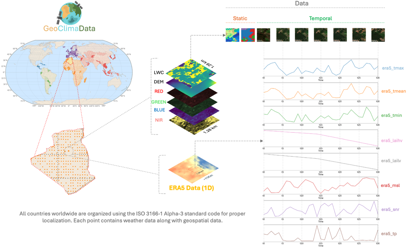
Figure 1: Overview of the GeoClimaData dataset, showing the distribution of sampling locations and how Sentinel-2 multispectral time series are combined with static environmental data, such as elevation, and climate time series for each location.
The challenge of real-world satellite records
The research also revealed an important obstacle. Many conventional generative AI models perform best on relatively short and regularly spaced sequences. Real satellite records are rarely so tidy: they may cover many years and contain irregular gaps caused by clouds, satellite acquisition schedules or missing observations.
For AI, these gaps make it difficult to connect environmental events with ecosystem responses occurring much later. Errors can also accumulate as models generate increasingly long sequences.
To address this problem, the team explored transformer models. Transformers can compare different moments within a sequence and learn which previous observations are most relevant. Their ability to connect information over longer periods and deal more flexibly with irregular observations makes them particularly promising for Earth observation time series.
From observing change to anticipating it
The project results attracted interest from both researchers and environmental agencies. The next challenge is to demonstrate where these methods can provide a clear added value for operational environmental monitoring and decision-making.
DEEPVEEG does not yet provide a system capable of reliably forecasting future ecosystems. Instead, it demonstrates an important step towards using AI to explore plausible ecosystem responses to changing environmental conditions (Fig. 2).
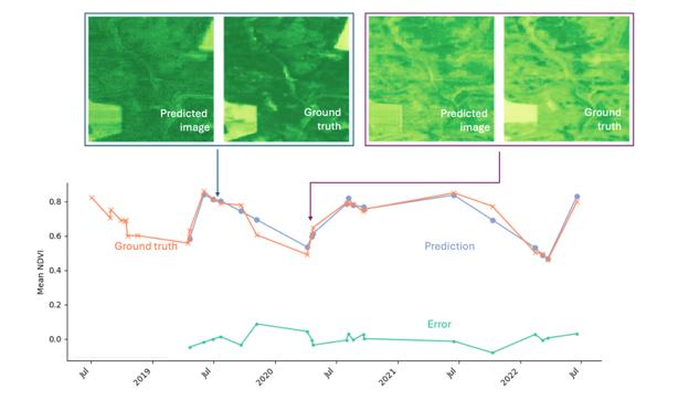
Figure 2: Performance of the time series predictions showing that the Transformer model is able to reproduce both the spatial patterns and irregular patterns based on historical Sentinel-2 time series.
By bringing together satellite observations, climate information and artificial intelligence, DEEPVEEG points towards a future in which Earth observation does more than document environmental change after it happens. It could also help us explore what may happen next — providing new evidence to support environmental planning and climate adaptation.
Project partners
KU Leuven: Stef Lhermitte - Enrique Apolo Apolo - Wouter Strauven