Published on 26 August 2022
In a context of constantly changing cities, urban mapping and related applications need to be increasingly accurate, fast and easy. The STEREO III project GENLIB promotes a concept that should help make mapping of urban environments using remote sensing data both more efficient and more accessible.
Cities are booming, so are the databases
Cities are growing faster than ever, and so does the amount of earth observation imagery covering urban areas. Remote sensing big data is now being enriched with airborne and spaceborne imaging spectroscopy, and this presents interesting prospects for the monitoring of urban areas.
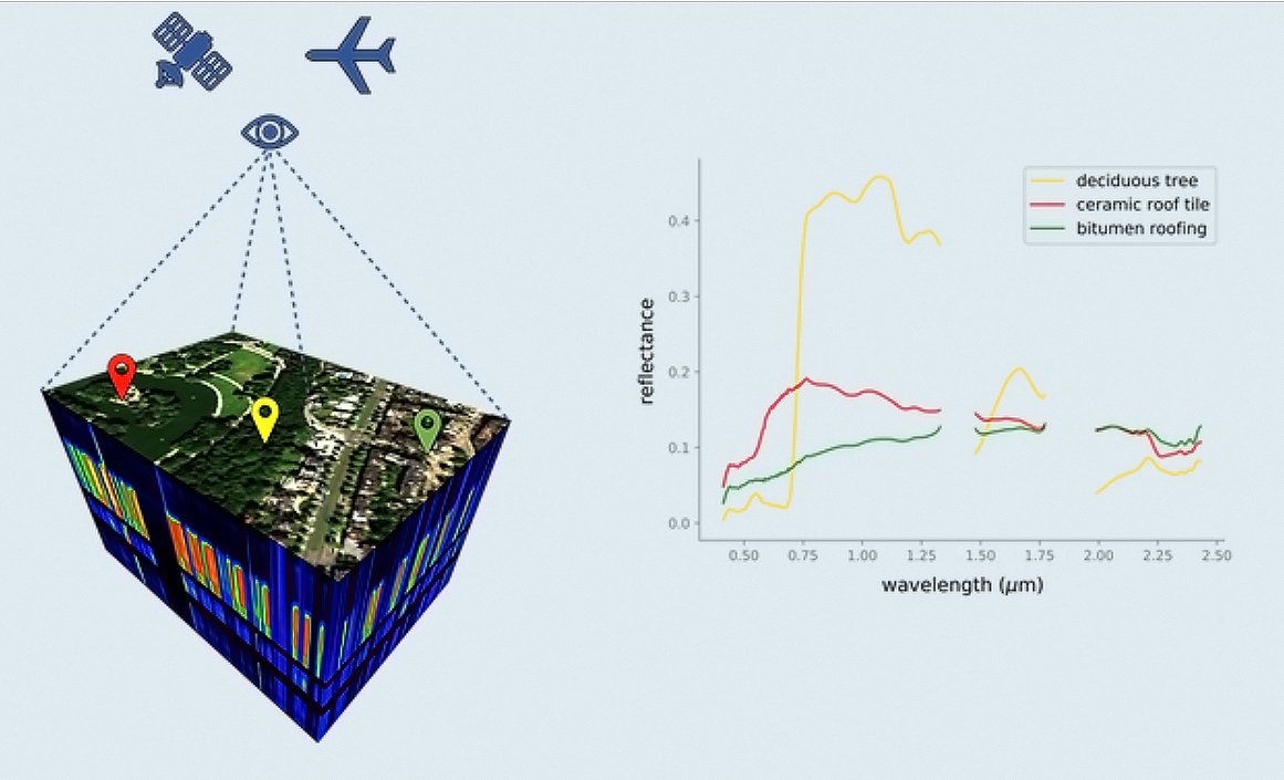
Cities are characterised by a very large variety of ground cover (buildings, roads, vegetation, etc.) which are often very small and very close to each other. They may even overlap, not forgetting the numerous shadow zones created by buildings. Under these conditions, it is very difficult to distinguish between the different ground covers solely on the basis of their spectral signatures.
Transforming Earth observation data into useful information therefore often requires the development of specific numerical models for each theme studied. But these models cannot be developed without high-quality training data (also called reference or ground truth data) for the different types of urban cover. Acquiring these data is generally done on a case-by-case basis and unfortunately takes up a lot of time and effort, in part due to the absence of a standardised approach.

Conceptual illustration of the Generic Urban Spectral Library framework. A GUSL is defined as a multi-site collection of richly labelled urban spectral libraries, equipped with the tools needed to query, transform, and apply these libraries for various mapping applications
The objective of the STEREO III project GENLIB (Developing a generic framework for library based multi-site mapping of urban areas) is to facilitate, rationalise and make more accessible the mapping of urban environments using remote sensing data. To this end, the project team, composed of members of the VUB, the KULeuven and the DLR, proposes the concept of a Generic Urban Spectral Library (GUSL).
The main hypothesis of GENLIB is that such a library, once it becomes sufficiently representative, can be used to perform accurate mapping with any optical sensor, on any site and for any application, assuming that the used image data is reasonably suited for the task.
The GUSL is envisioned to be distributed through the openly accessible SPECCHIO data system and grow dynamically with contributions of new spectral libraries from a benefiting user community. As such, the GUSL will become spectrally representative for an increasing diversity of urban areas.
|
A spectral library is a collection of labelled spectra that is usually accompanied by at least some metadata (e.g. on how, when and where these spectra were acquired). Spectra or spectral profiles describe the amount of sunlight that is reflected/absorbed by different surfaces. Reflectance can vary over wavelengths depending on the (bio)physical or chemical properties of the surface being measured, resulting in unique signatures that allow us to identify those surfaces (and sometimes even their condition). If a surface type is pure, i.e. it consists of only one material, it is called an endmember. Spectral libraries typically contain only pure endmember spectra labelled with their corresponding cover type. Endmember spectra can be measured with laboratory/field spectrometers (near or on the ground) or sampled from remote sensing imagery (from the sky). While ground measurements are typically more accurate, they are also more expensive to acquire. |
An experimental library...
To highlight the feasibility of the GUSL and illustrate its workings, the team first produced an experimental GUSL containing almost 9000 spectra from 8 source libraries and covering 10 cities in Belgium, Germany, the UK and the USA. It contains over 50 artificial and natural cover types (see illustration below).

Composition and spectral variability of the VUB-KUL spectral library of Brussels, one of the source libraries of the experimental GUSL. This spectral library can be downloaded from the Zenodo Open Access platform.
To manage data from these 8 source libraries, all with different band set definitions, (see illustration below), the team developed a Python-based module called GSL-tools. Besides providing functionality for automatic GUSL spectrum resampling and relabelling, GSL-tools also addresses spectral library construction, optimization, and synthetic mixing.

The band set definitions of the different source spectral libraries included in the experimental Generic Urban Spectral Library, illustrated here by means of band density over 100 equally sized wavelength intervals. The average Full Width at Half Maximum bandwidth is plotted on top for each corresponding source library.
…put to the test
The team then put their experimental library to the test via 3 experiments that consider common GUSL use cases.
The first use case handles spectral library production, which remains a challenging task requiring some expert knowledge. Here the team emphasizes the so far underused potential of image-derived spectral libraries, and showed how the GUSL can facilitate the production of such libraries.
The second GUSL use case tackles its application for high-resolution land cover classification in absence of local spectral information on the image being mapped.
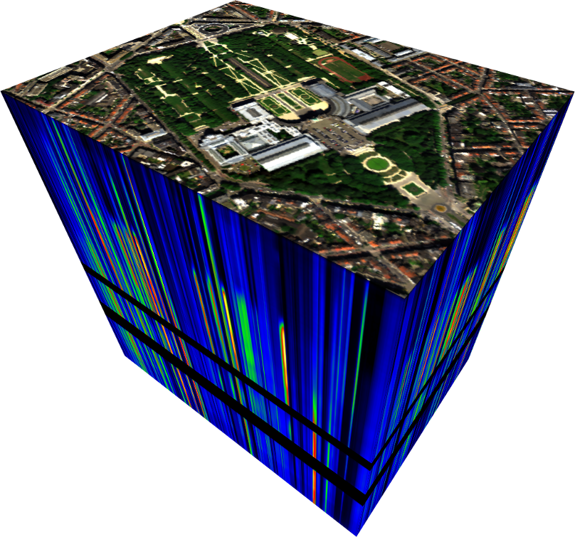
Representation of a hyperspectral image in the form of a "datacube" (3D data cube in which each pixel provides local spectral information on a large number of contiguous bands in a scene of interest) of the Cinquantenaire Park in Brussels.
The third use case addresses the application of the GUSL for medium-resolution subpixel fraction mapping. While urban fraction mapping typically draws on the Vegetation-Impervious-Soil or similar mixing frameworks, the team investigates if the GUSL can be leveraged to perform fraction mapping targeting a thematically enhanced mixing framework with 6 generalized material classes: Ceramics-Minerals, Metals, Plastics, Semiconductors, Vegetation and Water. For this purpose, use is made of a simulated hyperspectral EnMAP satellite image of Brussels.
|
The per-pixel classification allocates to each pixel of the image one and only one land cover class. Sub-pixel classification allows each pixel to have multiple and partial allocations to identified classes (e.g. in the case of a pixel with vegetation and asphalt when a tree partially covers a road). |
The favourable outcomes of these proof-of-concept experiments indicate that the GUSL can help produce spectral libraries and deliver detailed and accurate maps with limited user input, even under challenging conditions, e.g. when local spectral information is partially absent.
The GENLIB project has therefore underscored the potential of multi-site spectral library collections for more efficient urban mapping. The project's developments have demonstrated the feasibility of such a GUSL spectral library as well as its usefulness for different types of urban remote sensing users.

 More information
Project sheet: GENLIB (Developing a generic framework for library based multi-site mapping of urban areas)
Website of the GENLIB project : A Generic Framework for Library-based Mapping of Urban Areas