Published on 24 June 2021
More than 70% of the world's sandy coastlines have been undergone net erosion over the past decades. Understanding the elements that influence the spatial and temporal dynamics of beaches is therefore fundamental for taking protective measures.
Within the framework of the STEREO project RS4Mody, researchers from the VUB, VITO and UCL have set up camp on the Belgian coast at Groenendijk beach in Koksijde and have gathered a maximum amount of information by means of drone flights equipped with a multispectral camera and LiDAR aerial campaigns, as well as by compiling more than 25 years of historical data (aerial and field photos, maps, LidAR data, literature, etc.).
Insufficiently studied protective sandbars
The intertidal zone, or foreshore, is the part of the coastline located between the extreme limits of the highest and lowest tides. On the Belgian coast, this zone is subject to significant tidal ranges (over 4 metres). In these so-called macrotidal environments, the beaches are generally characterised by multiple intertidal bars that can sometimes extend for more than 5 km along the coast. These sandbars play an important role in protecting the beach from storm erosion by reducing wave energy on the coast.

Aerial image of the sandbars at the study site in Koksijde
Most studies on intertidal bar morphodynamics focus on the short term, with observations of changes in their morphology on a daily, weekly or sometimes monthly scale. Due to the numerous challenges associated with a dynamic environment where morphological response influences driving factors, limited studies have tried to compare bar morphodynamics at different time scales. There is also a lack of information on their large-scale (>1km) characteristics.
Better understanding through RS4MoDy
The STEREO project RS4MoDy studied and mapped the behaviour and morphological evolution of a macrotidal barred beach both in the short term (storm event) and in the long term (>25 years). The researchers analysed the relative roles of the different meteorological and marine factors that influence the behaviour and evolution of the sandbars (wind speed and direction, wave characteristics, water level...).
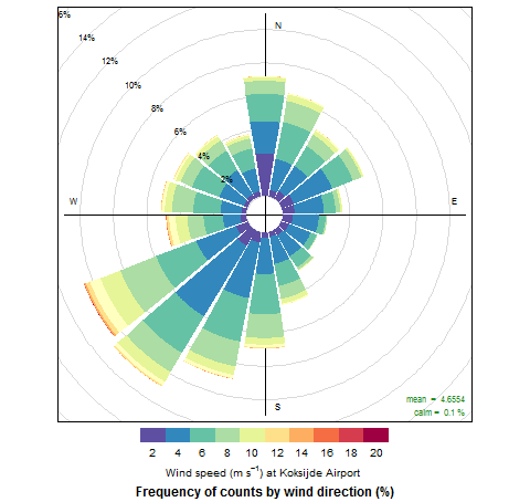 |
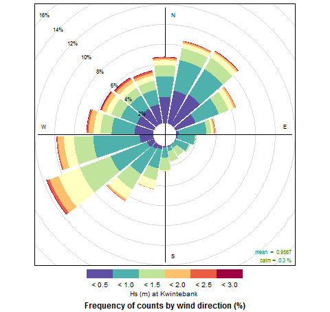 |
Annual wind and wave roses from 2000 to 2019
Historical high spatial resolution airborne LiDAR data provided details about long-term morphological changes. Pre- and post-storm drone flights equipped with high-resolution cameras were performed to assess storm impact, as well as the recovery of the bars. Hydrodynamic monitoring with sediment and internal sandbar structure analyses was also carried out to develop and implement a conceptual model of macrotidal barred beach morphodynamics that incorporates short and long term impact factors and sediment characteristics.
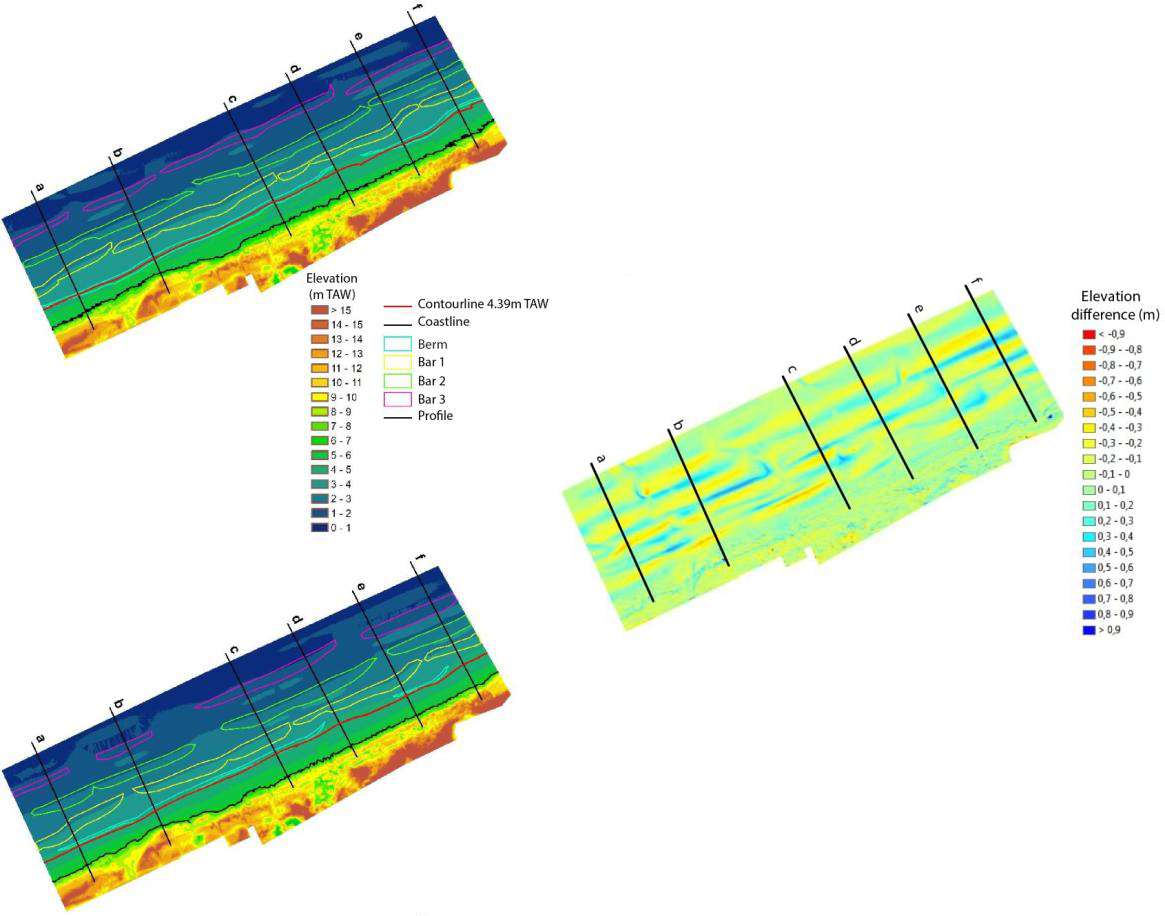
Pre- and post-storm Digital Elevation Model (DEM) with extracted coastline indicators and beach morphological features (left) and difference between the DEMs (right)
The researchers were able to show that the model developed during the project is able to predict the evolution of the integrated morphological characteristics of the beach over time. These results allow a better understanding of the dynamics of these beaches and provide very useful information to the authorities in charge of coastal management and safety.
More information
Members of the RS4MODY project team
 Anne-Lise Montreuil |
 Robrecht Moelans |
 Patrick Bogaert |