Published on 6 September 2019
At the Royal Belgian Institute of Natural Sciences, right next to the exhibition halls populated by dinosaurs, many scientists carry out research to better understand and manage our environment.
Among them, researchers from the STEREO project PONDER are trying to improve methods for mapping water turbidity, an important factor for marine organisms, and to estimate the spatial evolution of sediment transport.
For this type of application, in situ measurements are very expensive. Because of that, researchers are increasingly turning to satellite images.
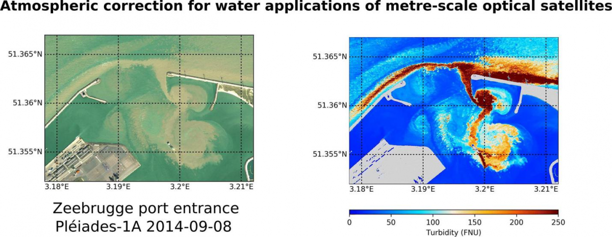
Pléiades image of the Zeebrugge port entrance (left) and water turbidity map (right)
Aerosols that hide sediment
Before they can be used, satellite images must undergo a process called atmospheric correction. Aerosols in the atmosphere affect the light recorded by sensors on board satellites. The images must therefore be'cleaned' of the effect of these fine particles that reflect and absorb light.
As part of the PONDER project, the Institute's researchers were able to develop an atmospheric correction algorithm that uses very high spatial resolution data, such as Pleiades images, to extract very detailed information on turbidity and sediment transport.
40 years' worth of satellite data
It is obviously very interesting to study the long-term evolution of parameters such as water turbidity.
Over the past 40 years, many satellites have collected impressive amounts of data, so long time series are available. However, between Landsat 5 (launched in 1984) and Sentinel-2 (which has only been in orbit for two years), technology has evolved significantly. Current sensors are not designed like those of 20 years ago and the image formats of these satellites are sometimes very different.
To align these data series over time and compare them, a unified processing method was essential.
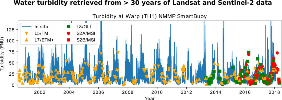
Chronology of turbidity in the water of the southern North Sea, based on in situ measurements (solid line) and derived from satellite data. The last 20 years shows a good match between both.
Unified processing
Quinten Vanhellemont, a researcher in the Institute's Remote Sensing Group, has developed an atmospheric correction algorithm applicable to all types of images, as well as software for automatic and consistent image processing. This resulted in standardized and easily interpretable data sets that can be used to extract water reflectivity and other parameters such as turbidity. The results were validated with long time series of in situ measurements recorded using instrumented buoys.
These data made it possible, for example, to observe the impact of the extension of the ports of Zeebrugge and Ostend on sedimentation on both sides of the port walls.