Published on 24 September 2021
The poles play a key role in the climate system and are both actors and particularly sensitive to the effects of global warming. Their close monitoring is therefore fundamental.
The recently completed STEREO project MIMO (Monitoring melt where Ice Meets Ocean) aimed to improve the monitoring of the Antarctic ice sheet in the context of a changing world. Using SAR satellite imagery, the project made major advances in quantifying parameters used in models to predict the ice sheet behaviour.

Ice displacement velocities obtained by interferometry on the Roi Baudouin ice shelf.
|
Excess ice velocities monitored by interferometry Several techniques using SAR images can be used to map ice surface displacements and determine their velocities. One of these techniques is interferometry. In a SAR image, each pixel contains two types of information; amplitude information, which is related to the reflectivity of the ground, but also phase information, that is related to the distance from the satellite to the ground. By subtracting the phase of two SAR images taken from different dates, we make an interferogram. |
Fossil energy, an expensive luxury
The use of fossil fuels marked the beginning of the Anthropocene. Although renewable energies are in full development, fossil fuels, which emit greenhouse gases, still account for more than 80% of global energy consumption.
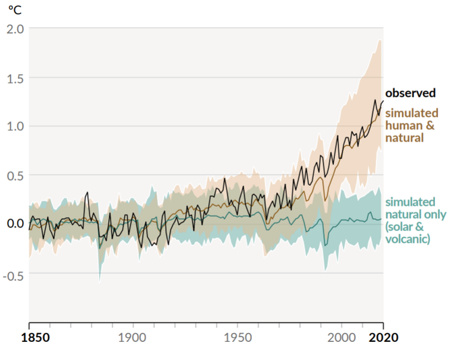
With a population getting closer to 8 billion inhabitants (still growing) and CO2 annual emission (or equivalent) around 6-7 tons per capita (stable since 1970), Humankind is leaving an enormous footprint. Warming due to the increase in greenhouse gases, which has been known for 125 years now, has long since ceased to be just a theory; we observe and experience it on a daily basis.
|

The consequences of global warming are countless. Above is a graph showing the evaluation of risks related to global warming. Source: IPCC AR5 report, 2014. |
The oceans are absorbing a large part of the warming and one of the most visible and direct impacts is sea level rise, which is devastating as the majority of the biggest cities are located in coastal areas. Warming is amplified in the polar regions and the passing of critical tipping points can lead to irreversible melt of the largest ice sheets (Greenland and Antarctica), which would cause a sea-level rise of several meters in the next centuries.
Antarctica, a dam ready to collapse
Antarctica is the largest ice mass on Earth, set on a rocky continent. This mass undergoes gravity-driven displacements towards the ocean. In contact with the ocean, the ice starts to float and forms a floating ice shelf. These ice shelves, surrounding 70% of Antarctica, have an important role in keeping the Antarctic Ice Sheet stable. Ice shelves can be considered as the seatbelt of the Antarctic Ice Sheet and are acting as regulators of the ice flow by exerting what we call a buttressing effect (through local constraints in a bay or via topographic elements).
At equilibrium, an ice shelf gains as much ice as it loses. Due to factors such as increased basal melting and calving induced by warming, this stability is compromised for an increasing number of areas around Antarctica. Thinning or damage to ice shelves causes an acceleration of ice flow and a retreat of the grounding line, the boundary between floating and grounded ice.

70% of Antarctica is surrounded by ice shelves. Most of them are active regulators of the ice flow by exerting a buttressing effect. Source: Fürst, J. J. et al. (2016).
Antarctica is losing mass at an increasing rate, from 40 Gt/a in the 80s to 250 Gt/a in the last decade. Antarctica is the highest potential contributor to sea level rise. Its contribution was only 7% for the period 1971-2018 but has reached 14% as of 2016.
Contrary to any global-warming-induced undesirable events, sea-level rise has a long-term irreversibility and is likely to cause a complete shift in the geographic distribution of the world’s population. Understanding the mechanisms of ice shelves’ behavior is a crucial element when we study the climate change impacts. The MIMO project was born from this perspective.
SAR remote sensing, a Swiss knife to monitor ice shelves’ health
Ice shelves are subject to multiple geophysical phenomena that govern their behaviour and contribute to their destabilisation. Some models attempt to estimate their movement speed and thickness based on visual observations of damage rather than quantitative measurements. Similarly, the integration of crevasse propagation is not coupled with observations. Field campaigns are indeed difficult in Antarctica; limited to the summer periods, due to the cold and dark winter, their spatial coverage is often restricted and their resolution punctual.

Examples of geophysical processes influencing ice shelves: calving, hydrofracturing, crevassing, precipitation, surface/basal melting, circumpolar deep-water upwelling, katabatic wind, tidal mixing, grounding line migration and so on. Source: Dirscherl, M. et al (2020).
As a result of MIMO research, it is now possible to combine SAR (Synthetic Aperture Radar) remote sensing products with techniques originally developed for medical imaging to automatically detect cracks and monitor the location of the calving front (the boundary between an ice shelf and an iceberg).
The technique was tested on the Pine Island Glacier, which suffers from strong dynamics, large calving events and overall retreat of the ice shelf. The team used almost 200 SAR acquisitions from the Sentinel-1 satellite, from 2016 to 2020, with 6-day between images. The method requires a first step including a robust preprocess pipeline including calibration of images, log-transform to enhance contrast, speckle filtering and geoprojection in Antarctic Polar Stereographic. Then, the SATO filter used in 3D medical imaging and adapted by the team to satellite data, is used to detect the pixels corresponding to damaged structures. Applied to pre-processed images, the method provides as a final result the location of cracks and the calving front and has enabled the identification of important events.

Detection of crack propagation and calving front from the 2017-2020 time series.
The technique developed by the MIMO project team is therefore a major step forward for fracture monitoring and opens the door to quantitative results.
In the end, the MIMO project contributed to understanding the impacts of climate factors in the Ice Sheet monitoring. The study of small-scale changes (in space and time) on ice shelves is now possible thanks to the SAR images and techniques developed.
The results obtained during the MIMO project contribute to a better global understanding of the physical science of climate change. The scientific publications that have resulted from this research have already been used in the preparation of official documents, such as the recent IPCC AR6 report, required for the production of technical documents that help policy makers to make the right decisions regarding the Paris Agreement.
More information
STEREO project MIMO (Monitoring melt where Ice Meets Ocean)
Remote Sensing of the Earth in Relation with South Pole Monitoring