Context and objectives
![]()
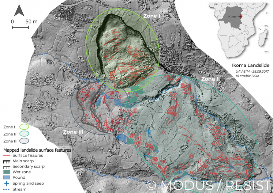
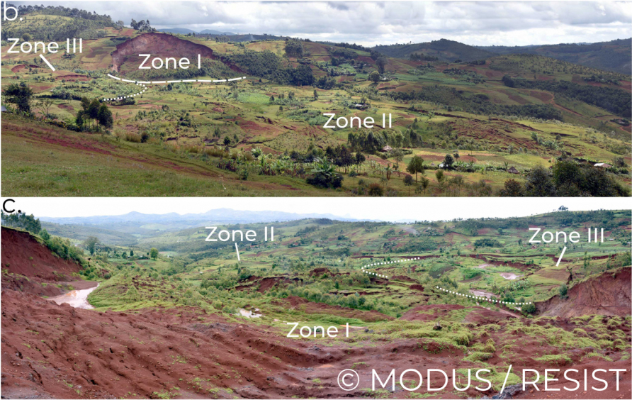
Landslides impacts are high in less developed countries, particularly in mountainous tropical areas such as the Kivu Rift (DR Congo, Rwanda, Burundi) where a combination of active tectonics, steep topography, intense rainfall and high population density is found. In the framework of the mother RESIST project (http://resist.africamuseum.be), the study of landslides in this region was instigated with the aim to create a regional landslide inventory – and with a focus on the effect of rainfall. MODUS aimed at going a step further into the characterization of the processes and mechanisms of landslide in tropical mountainous regions, with a special interest in improving our comprehension in how tropical environmental conditions (e.g., intense rainfalls, rapid weathering of rocks) and a growing human influence on landscapes control the occurrence and motion of large deep-seated slow-moving landslides. How to measure landslide motion in a data-scarce context was also an objective of this research project. Two landslides that represent end members of the landslide characteristics found in the area were studied:
- The Ikoma landslide – recent and rural: located in the rural environments of the city of Bukavu.
- The Funu landslide – old and urban: located in situated along the Lake Kivu in DRC
Project outcome
Scientific results
In this research we provided an unprecedented analysis of landslide processes and mechanisms in a tropical context. By investigating the development of landslides over decadal timescales, we could show that i) the relative importance of underlying landslide causes (such as weathering-related weakening of slope material) as driver of slope failure is emphasised in tropical contexts; ii) urbanisation can interfere with the natural behaviour of long-lived, deep-seated landslides. Detailed analysis of the movement of the landslides revealed a surprisingly tied relationship between landslide motion and rainfall-induced water changes in the slope, stressing intricated influences from climate, weathering, tectonics, and (sub)surface hydrology. We could also show how internal landslide dynamics (extension, compression, material redistribution, etc.) and interactions between different parts of the landslides exert strong controls on the overall motion. Alongside detailed investigations of the past and current mechanisms of landslides, this research also provides a case for the prime exploitation of the large and growing archive of short revisit satellite imagery. As such, the datasets created indeed offer a level of detail only available for a few landslides worldwide. While local knowledge and field characterisation will always remain crucial, we illustrated that remote sensing now offer opportunities to meet the needs to accurately quantify and monitor landslides all around the globe.
Insights into the landslide processes gathered in this research project help improving the evaluation of landslide hazard and mitigation in the area, but also across many other regions of the tropics where similar environmental and societal conditions are met. These findings also have wider implications for our understanding of landslide dynamics and how humans are interfering with landscape evolution. While our knowledge on landslide processes typically relies on the study of landslides developing in natural environments of high-latitude/high-income countries, this research paves the way for further analyses of landslides and other Earth surface processes in under-researched climate regions such as the tropics.
Societal (including environmental) relevance
Better understanding of landslide processes and mechanisms is at the centre core of the evaluation of the landslide hazard and risk. The information gathered in this project therefore serves for such evaluations in the area, and in other regions sharing similar environmental characteristics. Key findings to be considered are that i) tropical environmental conditions strengthen the role of underlying causes to landsliding, sometimes eluding the need for a high-magnitude dynamic trigger of instability to explain slope failure; ii) urbanisation can interfere (e.g., trigger destabilisation) with the natural behaviour of long-lived, deep-seated landslides. While rarely highlighted, the latter is of crucial importance considering the paces of urbanisation in many cities of the tropics. But our findings, by highlighting that landslide motion are controlled by sometimes small changes in slope stress, also provide indications on how to mitigate such hazard. When avoidance is not possible – typical in developing countries where informal urbanisation generally outstrips any regulation – mitigation strategies aiming at reducing water infiltration by a comprehensive management of all forms of surface water should undoubtedly be backed. We finally hope this work will contribute to highlight the importance of giving sufficient attention to landslides and other earth surface processes in tropical contexts where impacts are disproportionately high but research too uncommon. Through workshops and collaborations with the Université Officielle de Bukavu and the Protection Civile du Sud Kivu, this research project participated to the strengthening of research networks in Central Africa.
Products and services
Developed workflows based on the correlation and inversion of radar-amplitude images that is particularly adapted for the study of landslide dynamics in tropical context (and beyond). The high-resolution topographic datasets (from drone and optical remote sensing) are currently used in other research projects in the area.
Potential users
- Researchers involved in landslide and/or remote sensing studies.
- Maps, topographic datasets and inventories will be used for research and education purpose in local universities/research centres.
- Maps and the associated know-how are products of potential interest for local authorities involved in disaster risk reduction and land management.
Outreach
MODUS: keeping an eye on landslides
MODUS: aardverschuivingen opvolgen
| Project leader(s): | MRAC/KMMA - Natural hazards and cartography | |||
| Belgian partner(s) |
|
|||
| Location: |
Continent:
Country:
|
|||
| Related presentations: | ||||
| Website: | http://resist.africamuseum.be/MODUS | |||