Gepubliceerd op 7 maart 2017
A novel airborne experiment over the flat agricultural landscape of the Netherlands recently simulated, for the first time, images that could be taken by radar satellites orbiting in tandem.
Involving two aircraft flying in very close formation with each carrying a radar instrument, this first flight is part of a larger campaign in Belgium next month, in the framework of the joint ESA-BELSPO project "BelSAR".
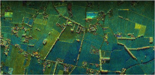 Fields in 3 D. First image taken using radar instruments on two aircraft. The blue–green areas are agricultural fields and the brighter features are mostly trees or houses. Copyright MetaSensing BV
... Christian Barbier from the Centre Spatial de Liege in Belgium explained, “There are many new applications that would benefit from information offered by two satellites working in unison instead of one. For instance, we could map the movement of glaciers in 3D, improve crop mapping and even create 3D maps of the world’s forests. Our trial next month will give scientists a unique chance to explore these new measurements and show how they can be used to improve agricultural monitoring from space.”