Context and objectives

![]()
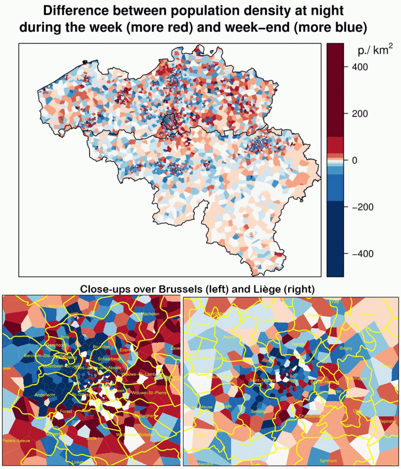
Studying the risks related to urbanization requires precise geodata and models. Yearly and dynamic (night - day, week day - weekend) population maps and up-to-date Land Use and Land Cover data can improve the assessment of impacts related to environmental hazards.
This shared cost project reinforces the operational SMARTPOP project financed by ISSeP. Its two main objectives are
- to update and improve existing Land Use and Land Cover maps using remote sensing;
- to implement and apply an activity based Constrained Cellular-Automata Land Use model for Wallonia.
The outputs can be used as decision-support tools by authorities dealing with spatial planning and environmental monitoring.
Project outcome
Scientific results
- Operational Land Cover and Land Use mapping frameworks;
- Dasymetric and dynamic population mapping protocols;
- Activity-based cellular automata Land Use and population distribution model to Wallonia;
- Enhanced data and tools for regional to local risk analysis.
Societal (including environmental) relevance
SmartPop strongly involved end-users since its start. An Implementation Group (IG) was created, including local and regional administration, for gathering their needs and discussing the results. Two surveys were carried out to define the LCLU needs. All preliminary reports were provided to the IG for review, which namely helped in tuning the LU model inputs (suitability and zoning map). Meetings with the Brussels and Flemish stakeholders were also organized to confront SmartPop objectives and outputs with their works and discuss how these could lead to national compliant datasets.
The new LCLU mapping prototypes showed great promises for end-users for fine-scale territorial planning and environmental monitoring activities. Due to this strong demand and INSPIRE, the regional authorities are now funding the regional application inside the project Walous. The Walous methodologies and specifications are in continuity with the ones proposed in SmartPop but integrate newer data as well as Sentinel imagery.
Demands for fine-scale population density mapping appear to be important at the administrative level. Indeed, the annually-produced data at the level of statistical sectors are difficult to implement in terms of risk estimation or management models (e.g. flooding zones, drainage areas, etc.). The new data provided by SmartPop are namely integrated in air quality and regional risks models by ISSeP for the regional administration.
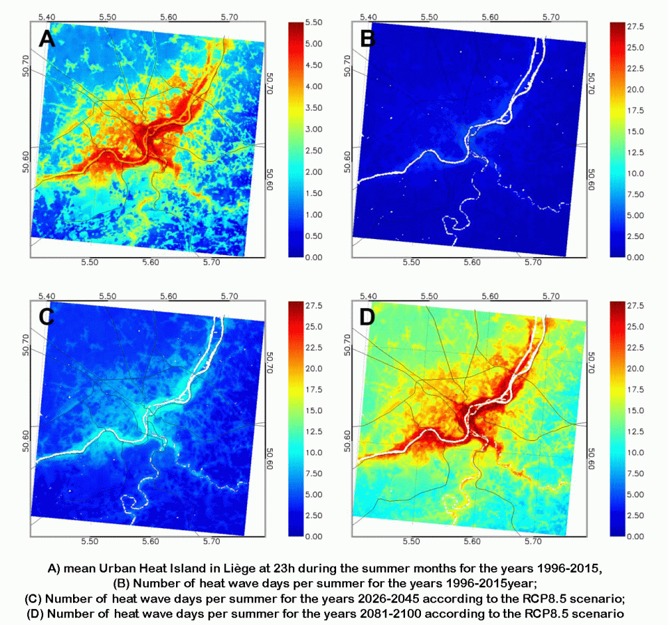
The two scenarios (business as usual and ‘Stop au béton’) of the Activity-based cellular automata Land Use and population distribution model are now being discussed with the relevant authorities in order to develop sustainable spatial planning strategies. Perspectives include the integration of the future regional Land Use map produced in Walous (due in 2020, and representing the year 2018) and implementation of more specific scenarios. The Urban Heat Island modelling is being discussed with city administrations for a smarter planning of the local environments.
Products and services
- Updated Land Cover and Land Use maps over the city of Liège;
- Dasymetric mapping tools;
- Dynamic population methodology and maps;
- Multi-temporal population maps and simulated Land Use maps;
- Results presented as WebGIS, geoservices and/or mapping protocols.
Potential users
- Public authorities :
- Direction Générales Opérationnelles du Service Public de Wallonie (SPW)
- Agence Wallonne de l’Air et du Climat (AwAC)
- Institut Scientifique de Service Public (ISSeP)
- Institut Wallon de l’Evaluation, de la Prospective et de la Statistique (IWEPS)
- National Geographic Institute (IGN)
- SPAQuE
- Cities (Namur, Liège…)
- Flanders and Brussels administration
- SPF-Finance
- …
- Research centres and universities, incl. Conférence Permanente du Développement Territorial (CPDT)
- Consultancy firms in spatial planning and environmental monitoring
- - …
Outreach
SmartPop: Cities hit by the heat
SmartPop: Coup de chaud sur les villes
SmartPop: Steden kreunen onder de hitte
| Project leader(s): | ISSeP (Institut Scientifique de Service Public) | |||||
| Belgian partner(s) |
|
|||||
| Location: |
Country:
Region:
|
|||||
| Related presentations: |
|
|||||
| Website: | http://www.smartpop.be | |||||