Published on 12 January 2021
The missing link of the green network
Garden related policy that strives for the optimization of the garden complex has only recently started up. Garden policy initiatives require objective data and monitoring of land cover and use, management, and policy effects. To date, reliable, systematic and integrated elementary base-line data on gardens - let alone extensive datasets - are almost completely missing in Flanders as well as elsewhere. Their private character is one of the main barriers.
To support garden research and policy, there is a clear need for more detailed information on and monitoring of garden cover, use and management.

Summer 2015 orthophoto of the study area (40 cm resolution) showing garden parcels and buildings larger than 20 m²
The GARMON (The GARrden MONitoring) proof-of-concept study, funded by the STEREO programme and the Flemish region, focused on the development of a garden monitor through the integration of existing remote sensing techniques. Both airborne and spaceborne remote sensing technologies were combined and its potential to locate and characterise garden and garden complexes were explored.
The goal was to explore image processing techniques to extract in a spatial explicit way the location and area of gardens and area of (and ratio’s between) different garden cover components (e.g. trees, grass, low green, sealed surface, and water).
From definition to map
The first step was to define a garden from a technical point of view. The team, consisting of members of KULeuven and Informatie Vlaanderen and coordinated by the Departement Omgeving of the Flemish Region, defined a garden as an area used for cultivation and recreation, which is located close to buildings and which cannot be cultivated solely for production purposes (agriculture).
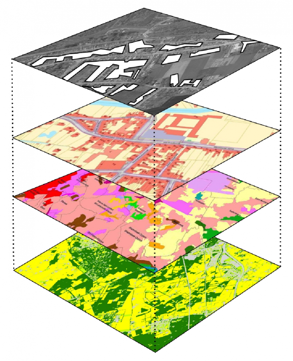 Based on the knowledge of existing datasets for the study area of Leuven a GIS (Geographic Information System) workflow was established. The workflow to select polygons was used to create a 'Garden' layer for the study area of Leuven, which was subsequently validated.
Garden characteristics based on regional available remote sensing data (aerial imagery -both optical RGB and LiDAR-) are added.
This result was also compared and validated with available land use data that list buildings and this for the whole of Flanders.
The result was a first garden map for Flanders that is helpful to start a 'garden policy' on a regional and local level.
Satellite images and ecosystem services
The project team then evaluated the added value of high-resolution satellite imagery such as that provided by the Pleiades and SPOT satellites to characterise garden cover. Using an object-based classification method, the researchers could achieve levels of accuracy similar to those obtained using aerial imagery.
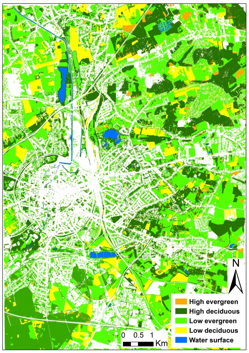
Green map for Leuven in 2015 as a result of an object-based classification (OBIA) of Pleiades and seasonal SPOT images.
Yet, through the addition of seasonal images, a winter and a summer image, they could differentiate between deciduous and evergreen vegetation cover within gardens. This latter is important information when studying the ecosystem service provisioning of urban vegetation.
The data from the GARMON project can now be used to quantitatively describe the extent, composition and configuration of the garden complex in Flanders and will be incorporated into the RURA 2.0 (Ruimterapport Vlaanderen).
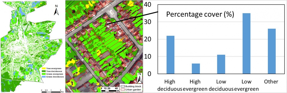
Example of the overlay between the garden parcel map and the green map for a building block in Leuven. This overlay allows to calculate the percentage of vegetation cover per garden parcel.
The final results will also be presented to relevant governments and stakeholders. At local level (such as cities and municipalities) the results can make a possible contribution to supporting green policy.
Some results such as the garden statistics per building block will be distributed as open geodata. The Flemish Administration engages itself to create updates from both geographical outcomes on a regular basis.
More information
STEREO project GARMON (The Garden Monitor - mapping and characterizing gardens using remote sensing)