Published on 25 September 2020
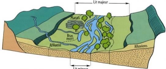
River and riparian area management in Wallonia
Since the end of the last century, river management has become more and more multifunctional: flood risk mitigation, growing of urbanization, natural habitat protection and endangered species conservation.

Riparian areas of the Amblève (Amel, Belgium)

The image above illustrates an example of an intervention carried out in the riparian zone (bank reinforcement by bioengineering).
In this context, Wallonia has started to review the river management legal framework in order to gather at the scale of a river management units (ca. 1-3 km long) all the actions planned by the different public administrations related to river bank and riparian zone management.
|
|
Monitoring 12000 km of river on a 6 years’ basis: can we do it with remote sensing?
To plan management actions, river managers need a high diversity of parameters related to riparian vegetation (location, height, growth, …) as well as river morphology (sinuosity, shape of river banks, …). Such monitoring tasks were simply not possible to foreseen using traditional field approach when considering the spatial extent (up to 12000 km long) and the revisiting time (6 years).

More than 12000 km of river flow across Wallonia. Characterizing with remote sensing their riparian areas implies to characterize the entire territory (ca. 16 000 km²)
That is why the STEREO III RiReMo project team wanted to develop remote sensing tools for the automated analysis of the hydrographic network and the riparian zones.
In terms of remote sensing technologies, the project was mainly based on regional 3D data provided by aerial LiDAR survey as well as photogrammetric 3D point cloud derived from regional annual orthophoto surveys. Such datasets present an important potential as they allow to characterize the height of every tree in the entire region on a multitemporal basis. As all these datasets are acquired on a regular basis by the administration, the reproducibility is important, ensuring the further use of the transferred methods.
First regional characterization of riparian areas and technology transfer
The RiReMo project characterized the entire river network of Wallonia (12000 km) based on a multiscale and multi-temporal approach.
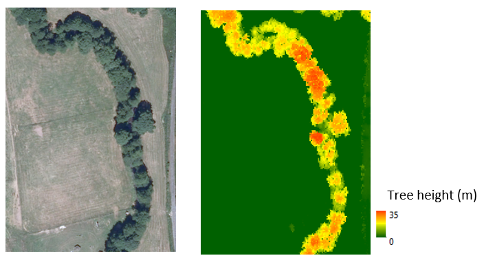
Measuring the height of the trees for this 500 m long riparian zone would have required one hour of field work, whereas the aerial survey captured this area in less than half a second.
In the frame of this project, a dense timer series of Canopy Height Model (CHM) covering the entire Walloon region on very high spatial resolution (≤ 1 m) for the years 2006, 2009, 2012 and 2016.
These datasets are freely available on the geoportal of Wallonia.
More information
RiReMo project (Riparian Remote Monitoring for river management in Wallonia)
Members of the RiReMo project team
 Adrien Michez |
 Philippe Lejeune |