Publié le 14 mai 2019
On May 14th, VITO released the new Copernicus Global Land Cover maps during ESA’s biggest Earth observation conference: Living Planet Symposium 2019. Thanks to a new novel mapping approach they offer typical discrete maps as well as continuous cover fraction layers for all 9 base classes making it possible to tailor the maps to the user’s specific needs.
The Copernicus Global Land Service, one of the 6 Copernicus services, assists public and private organizations in the preservation of the world's ecosystems. At the end of 2017, VITO released the Africa land cover map. They produced this map with a novel land cover mapping approach which produces next to a typical discrete map also continuous cover fraction layers for forest, grassland, shrub, and bare. Each cover layer provides the fraction of the pixel that belongs to the given class making it possible to tailor the land cover map to your specific needs.
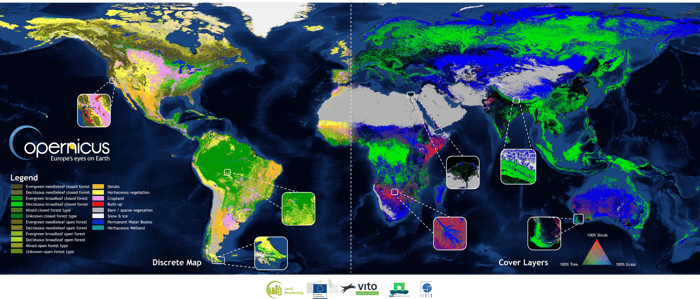
This collage shows the global discrete classification for the year 2015 (left side) and an example of combining 3 out of 9 cover fraction layers into a False Color Composite (FCC - right side).
Now VITO scaled up and extended their portfolio with the new Global Land Cover Layers, a discrete map and 10 continuous cover fractions (9 base land cover classes and seasonal water) to provide spatial information about land for a diversity of applications ranging from global forest monitoring, global crop monitoring, biodiversity and nature conservation to climate modelling.