Published on 3 March 2020
Today we celebrate World Wildlife Day, established by the United Nations in 2013 to raise public awareness of the importance of wildlife and the vital need for sustainable use of natural resources to preserve them.
We depend on the interaction between all elements of the biosphere for all our necessities: the air we breathe, the food we eat, the energy we use and the materials we need. This biodiversity, which is fundamental to our own survival, is threatened by the over-exploitation of species and natural resources. If we do not change our behaviour, nearly a quarter of all species are at risk of extinction in the coming decades.
Satellite data provide a real-time overview of the Earth's surface, while drones and mobile applications allow local communities to map their knowledge of local ecosystems. In this way, spatial data enable governments to make informed decisions on conservation and development.
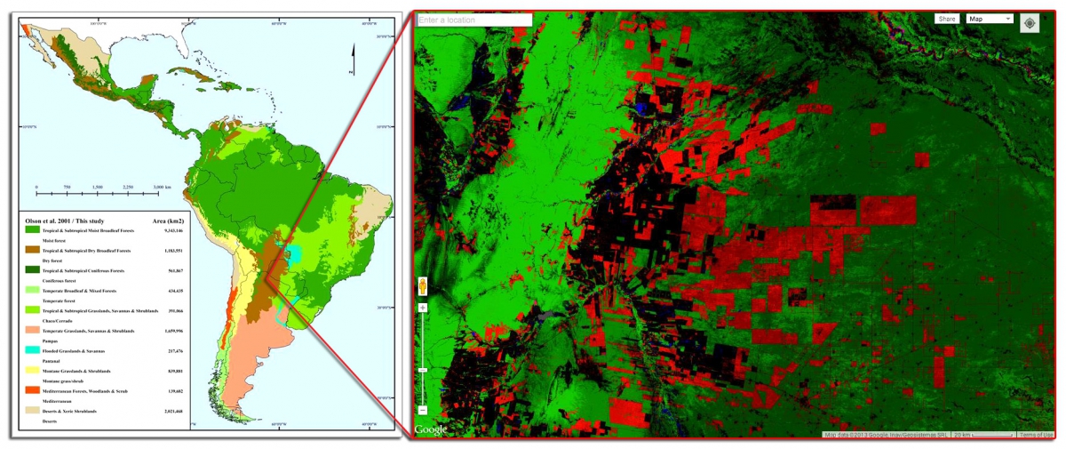 The Gran Chaco region of Argentina is a complex mosaic of forests, shrublands, savannahs, wetlands and grasslands that are home to over 400 species of birds, 150 mammals, 100 amphibians and reptiles and 3,400 plant species. As can be seen in the image above, deforestation, represented by the areas in red, is a cause for concern. Tropical and subtropical deforestation is one of the main drivers of the loss of biodiversity worldwide. Understanding forest dynamics is therefore an international concern and remote sensing is the basis for monitoring these changes. The objective of the STEREO project REFORCHA is to integrate multi-source remote sensing data, field observations and surface models to improve our knowledge of ecosystem degradation in dryland forests.

However, many countries still have little to no access to these data. A recent UN report revealed that spatial data have the potential to accelerate the implementation of the Aichi Biodiversity Objectives (OAB) and Sustainable Development Objectives (SDOs), but that there is a gap between the potential for using the data and the actual capacity of countries to mobilize them in the decision-making process.
This is why the United Nations Development Programme (UNDP) and UN-Environment have set up the UN Biodiversity Lab, an online platform that allows decision-makers and other partners to access global data layers, download and manipulate their own datasets and query multiple datasets to provide key information on sustainable development goals.
An introductory webinar on how to use this platform to support conservation and sustainable development goals is scheduled for March 24.
More information
- STEREO Project REFORCHA
- World Wildlife Day
- Introductory Webinar: Using the UN Biodiversity Lab to Support National Conservation and Sustainable Development Goals
Be sure to check out these older articles as well. Unfortunately they are still very relevant today:
- Deforestation in Brazil, poster developed for the exhibition Imaging the World's forests
- An irreplaceable habitat, an article created as an addition to the poster series "10 years of Imaging the Earth"