Published on 4 June 2021
Since 1974, World Environment Day, celebrated on 5 June, has been the United Nations' flagship day for promoting worlwide awareness and action for the environment.
Forests are essential to the health of our environment. They are not only considered as the lungs of our planet but are also a hotspot of biodiversity and provide numerous ecosystem services. Understanding where and why the forest cover changes, and how it affects ecosystems, has therefore become a research priority. While extensive research has focused on changes in humid equatorial forests, little attention has been paid to subtropical woodlands and open forests. Yet, there is evidence that the highest rates of agricultural expansion have recently shifted to these later biomes, notably in South America. Subtropical woodlands are adapted to long dry seasons whereby the vegetation developed different strategies to cope with extreme dry events. Their importance in terms of biodiversity and ecosystem services cannot be underestimated.
The numbers are impressive. Between 1984 and 2016, almost a quarter of the forests disappeared in the Dry Chaco region and nearly 10% of the remaining forests were degraded.
Researchers of the STEREO REFORCHA project analyze the intertwining of land-use dynamics, vegetation and soil degradation, following both conversions and subtle changes in subtropical woodlands. Together with partners from Argentina, they study ecosystem degradation in the Argentinean Dry Chaco, the largest continuous dry forest in the world.
By using the full depth of the Landsat archive, they characterized forest disturbances related to forest degradation across the entire Argentine Dry Chaco (about 489,000 km2) over a 30-year timespan.
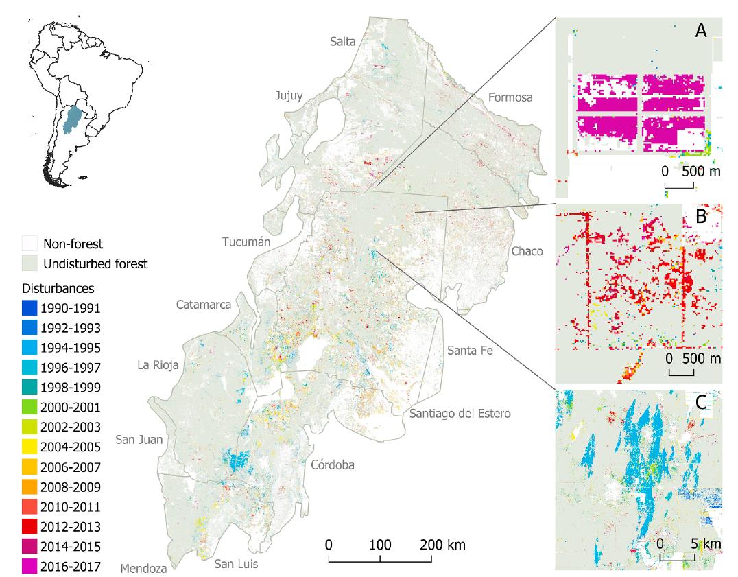
Map of the Dry Chaco showing the year of detection of disturbances (De Marzo et al., 2021)
To have more insights in the forest dynamics, the team monitored more than 60 forest plots by drone to sample patches of forest at different stages of degradation and analyze the vegetation disturbances. The cm-resolution drone imagery enabled three-dimensional vegetation reconstruction using structure from motion techniques (Gobbi et al., 2020).
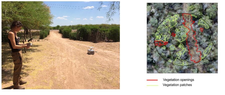
Reconstruction of forest structure using UAV-SfM (Unmanned Aerial Vehicle - Structure from Motion) techniques
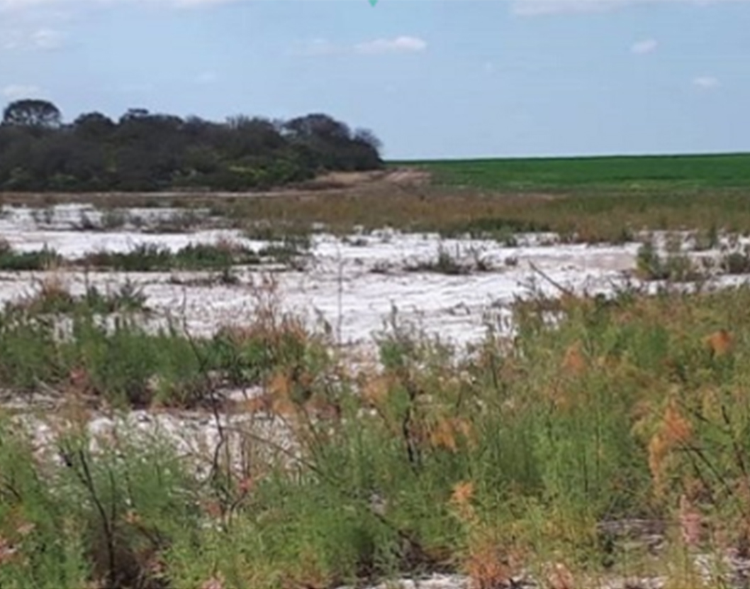
Forest degradation in drylands can lead to major shifts in soil water balance and soil salinization. Across the Dry Chaco region, farmers have reported severe salinization of their croplands that is happening several years after forest clearing. Timely and early detectiothe larn of soil degradation is necessary to prevent continuing degradation of the land. In the REFORCHA project, the team linked field-based degradation measures with observed long-term trends from satellite data to reveal the risk for salinization, and identify the areas that are most vulnerable to salinization. By integrating the remote sensing data in a land surface model, they simulated ge-scale effect of forest cover dynamics on the soil hydrology (Maertens et al., in review ).
 |
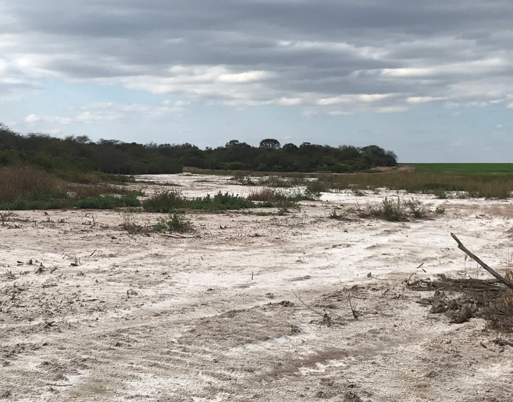 |
Croplands affected by severe soil salinization several years after forest clearing. Photographs made by Michiel Maertens
By integrating multi-source remote sensing data, field measurements and land surface models, the REFORCHA project has therefore made an important contribution to our knowledge of ecosystem degradation in dryland. These results and the techniques developed constitute reliable tools that will allow these ecosystems to be monitored better in the future and therefore better protected, in particular by making local decision-makers aware of the consequences of deforestation.