Context and objectives
![]()
GARMON is an application project with the Flemish administration. The proof-of-concept study focuses on the development of a garden monitor through the integration of existing remote sensing techniques. Both airborne and spaceborne remote sensing technologies will be combined and its potential to locate and characterise garden and garden complexes will be explored.
The data from the GARMON project will be incorporated into RURA 2.0 (Ruimterapport Vlaanderen), under the chapter on Natural Capital, part gardens. Garden statistics per building block will be distributed as open geodata. The Flemish Administration will create updates from both geographical outcomes (‘probable gardens’ and ‘building blocks with garden statistics’) on a regular basis.
Gardens (private green spaces) are strategic spaces for local environmental quality of life, being a substantial part of local green in living environments worldwide. Sustainable spatial and environmental planning and policy based on a thorough understanding of present and potential contributions of the whole of gardens, further called the garden complex, to this local environmental quality of life in relation to stewardship by people is crucial to realize their dormant potential. Garden related policy that strives for the optimization of the garden complex has only recently started up. Garden policy initiatives require objective data and monitoring of land cover and use, management, and policy effects. For example, spatially-explicit data on tree cover would help to quantify the temperature lowering capacity of richly structured gardens as a basis for the development of a neighbourhood specific policy on private and public green through a local green policy vision and plan. Insights in private tree management decisions on its turn opens the way for steering private practices towards policy goals. To date, reliable, systematic and integrated elementary base-line data on gardens - let alone extensive datasets - are almost completely missing in Flanders as well as elsewhere. Gardens are relatively inaccessible and challenging for systematic data collection. Their private character is one of the main barriers, as well as the ownership and management by thousands of gardeners - all decision-making agents - and extreme variations in size, appearance, management and uses. Region- or nation-wide spatially explicit baseline data for referencing representativeness of data is often missing. To support garden research and policy, there is a clear need for more detailed information on and monitoring of garden cover, use and management. The aim of this project is the development of a proof-of-concept of a garden monitor that is able to collect data on the ecosystem. The collected garden data will allow the calculation and optimization of regulating, maintenance and cultural ecosystem services of garden vegetation (like carbon sequestration, cooling effect, air quality, water regulation, habitat provisioning, recreation). This data would support policy preparation, policy execution and policy evaluation.
Project outcome
Scientific results
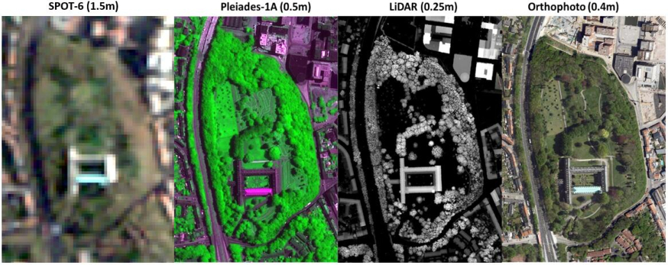
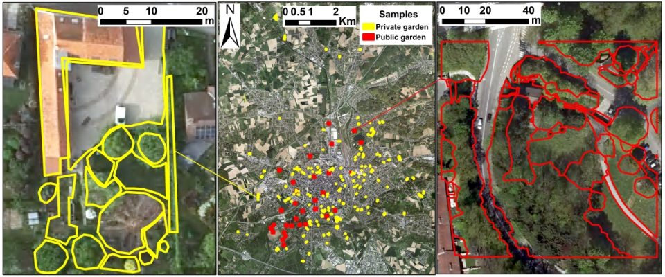
- A methodology to map the location and size of gardens.
- A methodology to map different garden components, e.g. calculation of area of and ratio’s between different garden cover components (trees, grass, low green, sealed surface, and water)
- A methodology to map the location and size of gardens derived from Pleiades/Sentinel2D3
- A methodology to map different garden components, e.g. calculation of area of and ratio’s between different garden cover components (trees, grass, low green, sealed surface, and water) derived from Pleiades/Sentinel2.
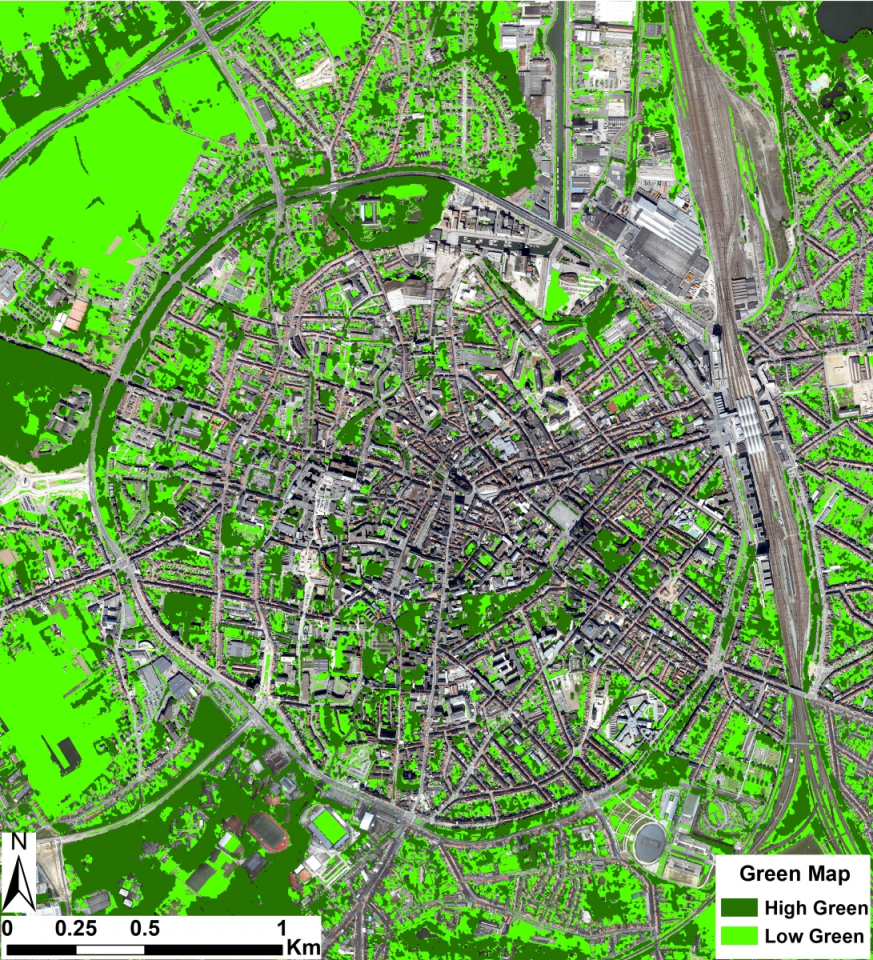
- Integrated garden maps combining info from previous deliverables.
Societal (including environmental) relevance
Gardens (private green spaces) are an integral part of the urban green and blue network with a substantial yet underexplored and underutilized potential for climate change mitigation and adaptation. The network of gardens, the so-called ‘garden complex’, can be considered as a blind spot for policy makers and urban developers. A truly integrated sustainable environmental policy at the city level can however only be achieved by assessing and unlocking the true potential of the urban garden complex for contributing to climate change mitigation and adaptation. The baseline garden maps provided in this project is an essential instrument to push research and policy on unlocking the climate mitigation and adaptation potential of the garden complex.
Products and services
- Dataset (map) of garden parcels in Flanders
- Thematic information (vegetation map or different components, private,…) of the study areas and/or Flanders.
Potential users
- Policy, government, civil society,
- A potential dataset for detailed inventarisation e.g. https://mijntuinlab.be.
Outreach
GARMON: Mapping and characterizing gardens using remote sensing
GARMON: Tuinen in kaart brengen en karakteriseren met behulp van remote sensing
GARMON: Cartographie et caractérisation des jardins par télédétection

| Project leader(s): | Vlaamse overheid - Departement Omgeving | |||||
| Belgian partner(s) |
|
|||||
| Location: |
Country:
Region:
|
|||||
| Related presentations: | ||||||
| Related publications: | ||||||
| Website: | https://omgeving.vlaanderen.be/nl/tuinmonitor-garmon | |||||