Image processing


Classification techniques
It’s a matter of class!
Objects of similar natures have similar spectral properties. That means that the electromagnetic radiation reflected by objects of the same nature is similar overall and these objects will thus have similar spectral signatures. Since the spectral signatures of the objects observed by satellites are converted into different colours in digital images, objects of the same kind will appear in closely related colours.
This property has been used for years to interpret aerial photographs and the images supplied by Earth-observing satellites. The interpreter places in the same category all the objects in an image that seem to have the same or closely related colour.
Since the colours in a digital image are merely a conventional transposition of numerical values, it is also possible to exploit the computer’s computational power to classify the pixels by their numerical values, which is to say, in the final analysis, by the corresponding objects’ spectral properties. This is the basic principle of image classification.
From their orbits satellites ‘see’ only the upper part of an object’s outer envelope. For example, satellites ‘see’ only the roof of a house. They will thus be able at best to classify buildings by their roofing materials, whereas the interpreter is probably more interested in the buildings’ functions (residential, commercial, industrial, etc.). This limitation is especially bothersome when it comes to identifying manmade elements of the landscape. Spectral signature analyses prove much more relevant for analysing land, crops, natural vegetation, etc. It is very important to take this basic principle into account in setting the categories of a classification scheme. These categories should always be based on the types of land cover rather than land use. For example, a car park and a building’s tarred roof correspond to very different types of land use, but their spectral signatures are so close that they will most likely be classified in the same land-cover category.
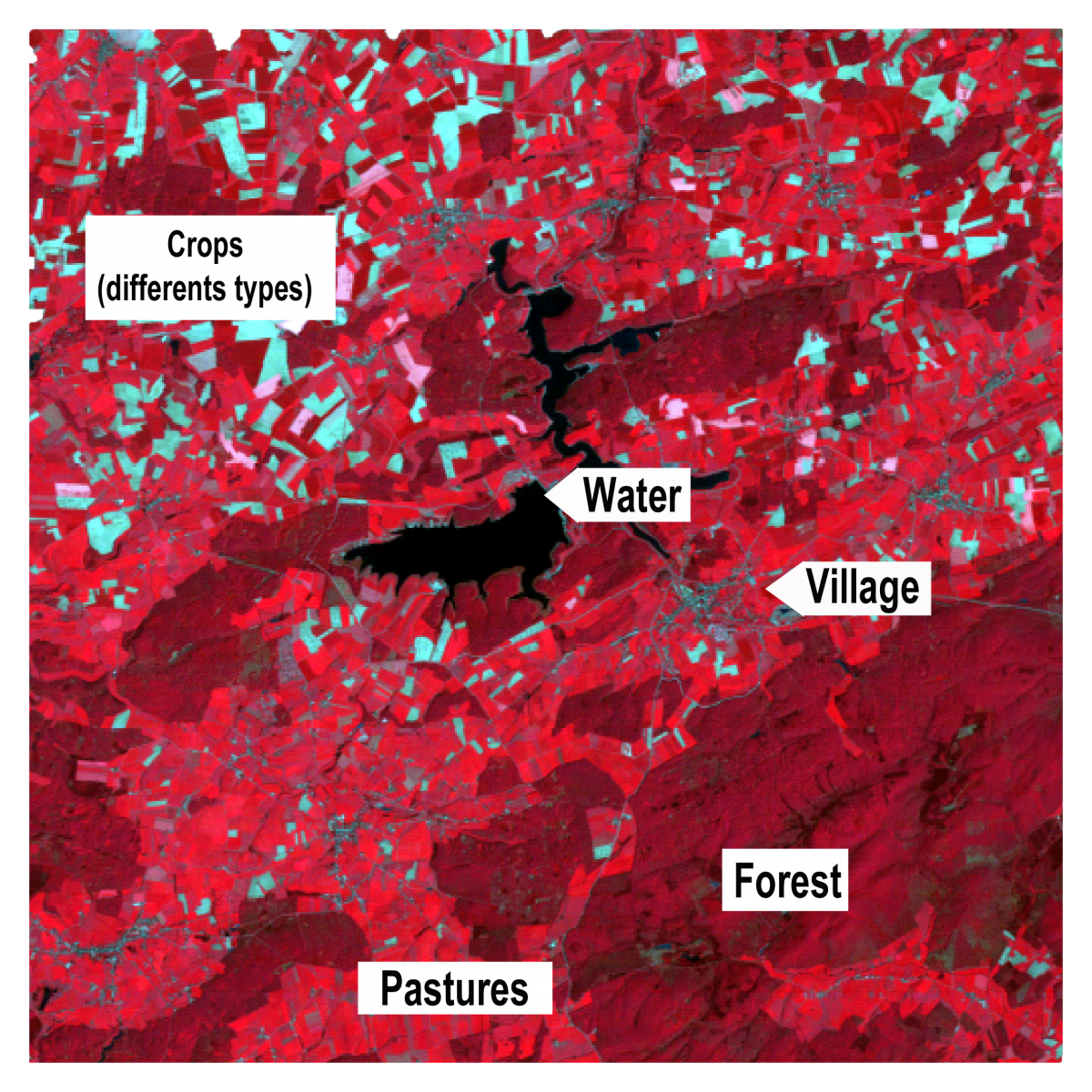
To illustrate the different classification methods we shall use a detail of an image recorded by Landsat 4’s Thematic Mapper on 15 May 1992. This excerpt corresponds to the Plate-Taille dam and Eau d’Heure lakes region (Philippeville area). The reference image is a false colour infrared coloured composition that matches the satellite’s near-infrared, red, and green channels with red, green and blue, respectively, in the representation.
In such a composition the lakes show up in very dark blue (practically black) and the roads and settled areas are a rather dark grey-blue. The broad-leaf forests that predominate in the area are dark red and the few stands of conifers show up as darker brown.
In this May image the grasses of the hayfields and pastures are very green and reflect a large amount of infrared radiation, which explains why they appear bright red in this composition. At this time of the year most of the grain fields have already reached a golden colour and no longer reflect the infrared radiation. They thus show up light blue in the coloured composition. A few fields have already been mown and the new growth shows up as light pink on the image.
Remote sensing research has developed many methods to classify digital images by the spectral properties of the objects present in the image. We shall outline them next.