Geographic Information System (SIG)

A geographic information system or GIS is a combination of hardware, software and procedures for storing, managing, processing and reproducing spatial data with data coupled to them.
There is nothing intrinsically unusual about the hardware or computer equipment needed for a GIS. But in order to be able to input the spatial data, the system needs to be equipped with a digitiser tablet and a scanner. With a digitiser tablet one can directly input the x,y map co-ordinates from a plan or map. Or one can also scan map material and then digitise the scanned image on a screen, with the aid of the mouse and the right software. In this way, the operator digitises point objects, lines and planes. The result is a vector structure. The objects must display mutual structural relations; this is called geometrical topology. During or after digitisation, one will also give to each object a unique code with which to identify the object.
One of the sources of geographical information for a GIS is remote sensing data. However, this information in the form of a matrix or raster differs from the prevailing storage of geographical data in vectors. If, in a study, one wishes to process remote sensing and vector data together, one will have to choose between a raster- or vector-oriented GIS. In the first case, one will transform the vectors into matrix data (V-R or vector-to-raster transformation), in the other case one will perform a raster-to-vector transformation. Although a V-R transformation is easier and the raster logic for the analytical algorithms is also much simpler, this structure entails a number of limitations. Most geographical information systems therefore work with a vector structure. This implies that the remote sensing data generally must be vectorised. One will usually work with classificated images, on which one automatically seeks to determine the borders, as well as to register the class values.
With the GIS software one can not only, as with other graphics packages, work with localised drawing objects, but one can also, by using the unique code which is coupled to each object, couple attributes to each object. These attributes are generally managed from this software in separate databases. Thus, one can couple to a closed polygon which represents a building attributes such as address, type of building, occupant or occupation, position of the building, owner, telephone number and all kinds of other data which one deems useful.
The collecting and processing of such hybrid databases (meaning that the data contain both geometrical elements and attribute information) is a great deal of work. However, once one has such a current data set, one can apply it in a variety of ways.
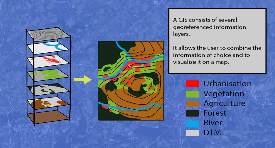
In so doing, a second aspect of this GIS software is important, namely the possibilities for analysing such spatial data. To do this in an optimal manner, one must make sure that the data are structured in thematic layers. Thus, a municipality (for example) will manage a file having one layer with parcel borders, one layer with buildings, one layer with inhabitant information, etc. Thanks to the spatial analysis possibilities of the GIS, one can pose all kinds of questions to the well-ordered system, such as "determine who lives in a zone of 50 m around this parcel of land". The system will provide the operator with a list of inhabitants who meet this condition. One can then use this list for all sorts of administrative purposes.
The third and visually most spectacular aspect of a GIS is that the answer to such a query of the system information can be provided not only in the form of lists or computer files, but the system can also display the result in the form of a map on a screen or on paper.
Thus, many maps are today being drawn with the aid of geographical information systems, whereby the geographical thematic information is frequently taken from remote sensing data. The availability of high-resolution images will allow remote sensing to be increasingly drawn upon for geometrical information gathering.