Image processing


Combination of images and other data: DEM and DTM
It is often interesting to combine digital satellite images with other, continuous, data sets. For example, such additional data can concern altitude, soil, demography, etc. However, one can only combine such an external data set with a satellite image if the data are spatially defined. This allows them to be converted into a common geographical reference system together with the image.
The data are then unambiguously established with three co-ordinates: an x- and a y-value in the same plane, and a z-value as the third dimension. On this basis one can visualise the change of z as a function of x and y in a 3D representation.
The z-values can thus be elevation data, in which case one speaks of a Digital Elevation Model (often abbreviated as DEM). In other cases one speaks of a Digital Terrain Model (DTM).
After a satellite image has been combined with a DEM, one gets a representation like that shown here (representation, in casu Hangzhou DTM) :
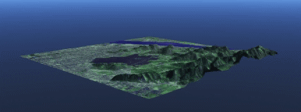
The combination of satellite images with a DEM is used for various applications: e.g. to produce images with perspective. Sometimes a DEM can also play an important role in a classification process. This is the case, for example, when mapping forests in mountainous regions, where the topographical factor helps determine what type of vegetation appears at a specific place. With the DEM one can then distinguish between different types of vegetation with the same spectral characteristics.