Image processing


Geometric and radiometric corrections
Geometric corrections
Geometry to the rescue!
The images acquired by Earth observation systems cannot be transferred to maps as is, because they are geometrically distorted. These distortions are due to errors in the satellite’s positioning on its orbit, the fact that the Earth is turning on its axis as the image is being recorded, the effects of relief, etc. They are amplified even more by the fact that some satellites take oblique images.
Some distortions, such as the effects of the Earth’s rotation and camera angles, are predictable. They thus can be calculated and correction values applied systematically. Satellites also have sophisticated on-board systems to record very slight movements affecting the satellite. This information is used mainly to correct the satellite’s position (when this is necessary), but can also be used to correct the images geometrically.
The producers of satellite images generally propose applying the most elementary corrections based on the satellite’s known information. So, in the case of SPOT images it is possible to buy geometrically uncorrected images (‘level 1A’ images). However, a large number of users work with images in which the distortions have been corrected systematically (‘level 1B’ images).
These corrections can be made without any special knowledge of the terrain. The accuracy of locations in these SPOT images is of the order of 500m.
To improve the precision of the corrections, reference points or Ground Controle Points, GCP (identified on a topographical map or in the field by GPS) must be available. The SPOT images that have been corrected in this way are accurate to approximately 50m and the data that they contain may be presented on a given map projection, meaning that the images are superimposable on a map.
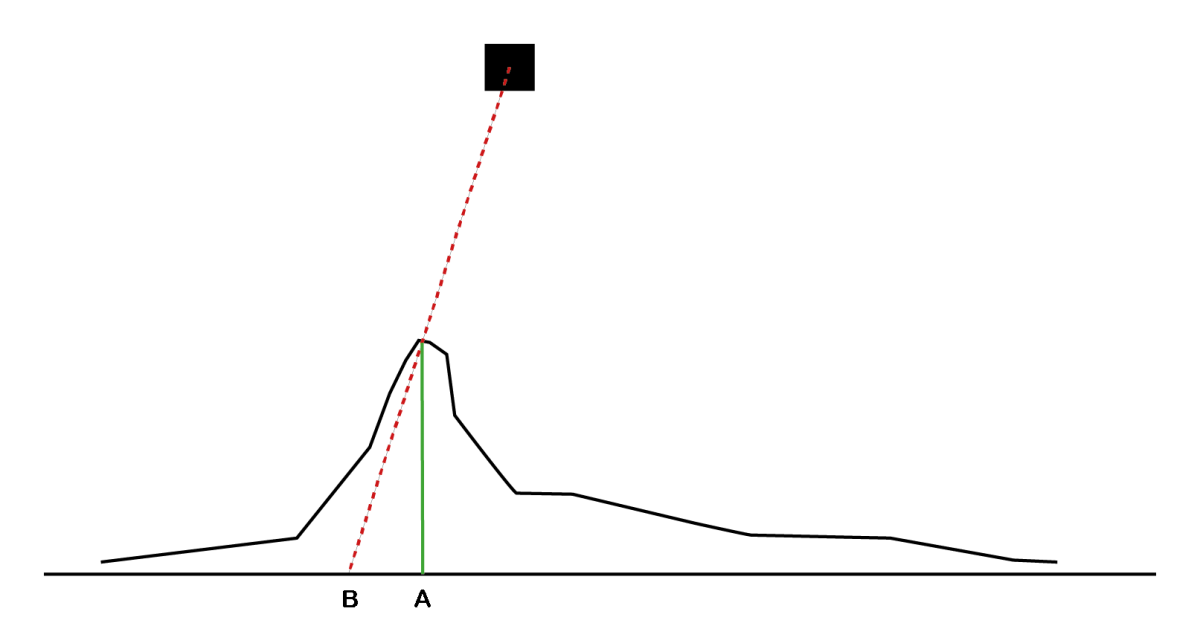
In very mountainous areas considerable distortion is caused by the parallaxes generated by the terrain, especially when the images were recorded from an oblique view. On the graph on the left point A corresponds to the position of the mountain peak on a map whereas point B corresponds to the image of the mountain peak as seen by the satellite. The distance A-B is the parallax generated by the difference in elevation. To correct these distortions one must have a digital model of the terrain, that is, a computer file giving the physical elevation of each pixel in the image. As a rule, it is considered that satellite images can be corrected under ideal conditions in such a way that the distortions do not exceed the size of a pixel (10m for a SPOT P image), but, if truth be told, these ideal conditions are rarely seen.
Radiometric adjustments
An ideal Earth observation system should be equipped with a perfect spectro-radiometer that can measure accurately and uniformly the amount of energy that is reflected by objects located on the Earth’s surface.
Unfortunately, the sunlight that illuminates objects is perturbed by its passage through the atmosphere and does not hit all objects at the same angle.
What is more, the light that is reflected by the objects must also cross the atmosphere before being analysed by the satellite’s sensors, and this journey also perturbs the signal.
These perturbations are due to the presence of gases and dust that can absorb and/or reflect specific wavelengths, thereby changing the radiation’s spectral properties.
What is more, the electronic processing of the rays that reach the sensors is also accompanied by some perturbations. Consequently, it is actually rather difficult to get accurate radiometric values from the data recorded by Earth-observing satellites. Now, it is sometimes very useful to be able to calibrate these data precisely, for example to compare the data recorded by different satellites or recorded by the same satellite at different times, and several solutions do exist to try to overcome these flaws. Some of them are based on complex mathematical models that describe the main interactions involved.

These models are effective. However, to apply them the values of certain parameters (i.e. the atmospheric composition) when and where the pictures are taken must be known, and this is seldom possible.
Other radiometric correction methods are based on the observation of reference targets whose radiometry is known. The surfaces of bodies of water, glacial ice caps, and expanses of desert sand are often used, but here too you can understand that actually making the corrections often is not that easy. In fact, the overwhelming majority of remote sensing research uses radiometrically uncorrected data.