Image processing
Geospatial maps
...or the right track
The usual procedure for producing maps is based on interpreting aerial photographs or satellite images to determine the natures and positions of the objects that must be on the map. Remote sensing data are used to prepare the map, but are not shown on it. In recent years remote sensing data have also been used as map backgrounds. That is, a satellite image is corrected geometrically to correspond perfectly to the reference system that is used, is processed for thematic (e.g. image classification) or aesthetic (e.g. colour composites) reasons and some annotations (villages’ names, contour lines, etc.) are added to make reading the map easier.
In preparing satellite image maps, specific graphical techniques help to combine image data with vector data. The satellite image forms a background against which vectorial information is depicted. These are, for example, a scale and a graduated grid. Planimetric and orographic data also improve legibility and provide important supplemental information. For quick and easy identification of the objects, one applies toponyms and other inscriptions. It is extremely important to select these vector data carefully. After all, the background information of the satellite image cannot be buried beneath the additional information, but the vector information should merely convert the image into a map. Satellite image maps are an ideal solution for hard-to-access areas for which one must quickly prepare up-to-date small- or medium-scale maps.'
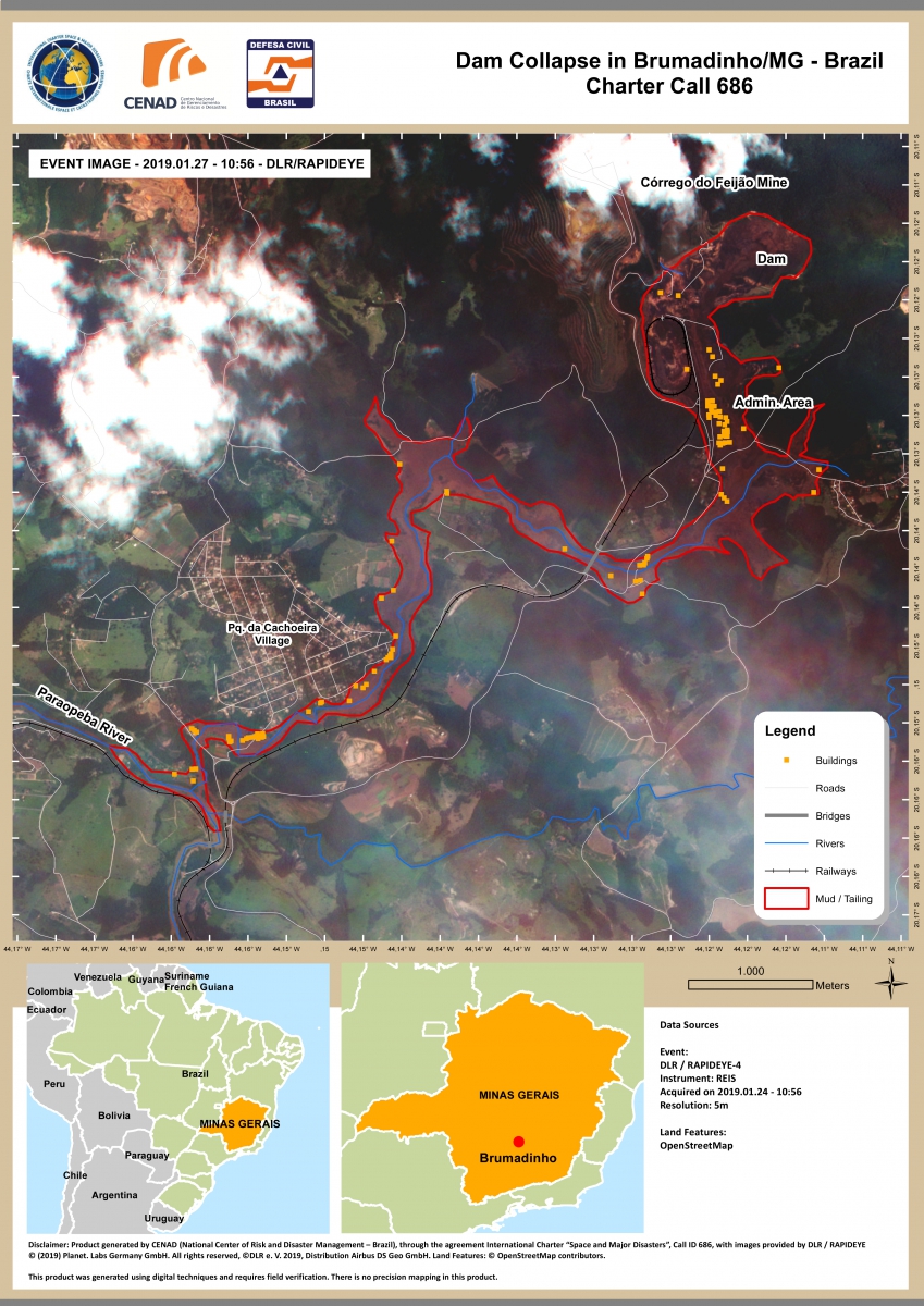
Geospatial map showing the extent of the mudslide 2 days after the Brumadinho dam collapse. Source: https://disasterscharter.org/web/guest/activations/-/article/dam-collapse-in-brazil-activation-596-
One of the most interesting applications of geospatial maps is emergency mapping. In the event of a disaster, natural or manmade, satellite imagery is an invaluable tool for organizing relief efforts, facilitating reconstruction operations and estimating damage.
Since 2000, the International Charter "Space and major disasters" – set up at the initiative of several space agencies – allows the priority acquisition and the free delivery of satellite data to organisations responsible for civil protection, rescue, defence and security, aimed at facilitating disaster management.
Since 2012, the Copernicus Emergency Management Service (EMS) uses satellite imagery and other geospatial data to provide free of charge mapping service in cases of natural disasters, human-made emergency situations and humanitarian crises throughout the world.
Emergency mapping transforms raw spatial data into relevant geographic information that is directly usable by these crisis management agencies or rescue teams engaged in the field. This mapping is based on the comparison of a reference state, before the event, with the state observed during the course of the event or immediately thereafter; both observations are obtained by means of observation satellites.
After geometric corrections and projection of images in a common reference system, the delimitation of the affected areas is carried out through digital processing using change detection algorithms. The final product, a geospatial map, is obtained by superimposing the footprint of the event on a cartographic reference background, which can itself be a true-colour or false-colour satellite image.
The geospatial maps obtained in such a way can display the location of the event, the extent of its effects, the intensity as well as the level of impact.
On January 25, 2019, a dam located southeast of the city of Brumadinho and managed by the largest mining company in Brazil, collapsed. A river of mud containing mining waste buried the site and several downstream villages, leaving at least 166 people dead. The geospatial map above shows the extent of the mudslide 2 days after the disaster, as well as the location of the buildings likely to be affected. The reference image used is a Sentinel-2A image at 10 m resolution dating from 22/01/2019 and the post-event image is a RapidEye image at 5 m resolution acquired on 27/01/2019.
More info on rapid mapping products: https://emergency.copernicus.eu/mapping/ems/ems-rapid-mapping-products
More info on the development of emergency maps and (in French): http://archives-fig-st-die.cndp.fr/actes/actes_2008/andreoli/TexteAndreoli.pdf


