IV - FROM DATA TO INFORMATION
4- HOW CAN WE ANALYSE IMAGES AND PRODUCE MAPS?
4.2- How can we measure surface variables?
The land surface and oceans exert a major influence on climate through the exchange of matter and energy with the atmosphere. Satellites provide a constant stream of data on the state and changes of the Earth's surface and are thus the information source of choice to study the Earth system using quantitative surface variables.
Parameters such as land and sea surface temperature, soil moisture content, biomass, primary productivity and radiation fluxes can all be derived by certain methods from the electromagnetic radiation received by earth observation sensors. However, this is not always that straightforward as the radiation recorded depends not only on the surface features we are interested in but also on other atmospheric or terrestrial factors.
Surface variables are determined in various ways by applying mathematical formulae and performing calculations with the spectral values recorded by satellites. Some surface variables are also derived from other surface variables. However, there are many uncertainties that make determining reliable values difficult.
This is the case, for example, for determining the temperature of the land surface, which is usually derived based on spectral values from thermal infrared sensors. The thermal infrared radiation emitted by the Earth's surface is related to its temperature but this relationship, however, is not unambiguous because of varying effects of atmospheric absorption and emission, variations in sensor viewing angles and changes in emissivity due to the composition of the Earth's surface. So to calculate the surface temperature correctly, we need more information than just the spectral data of the thermal infrared sensor. Among other things, we also need to know the type of ground cover present or the density of vegetation, what the absorption characteristics of the atmosphere were at the time of recording, etc.
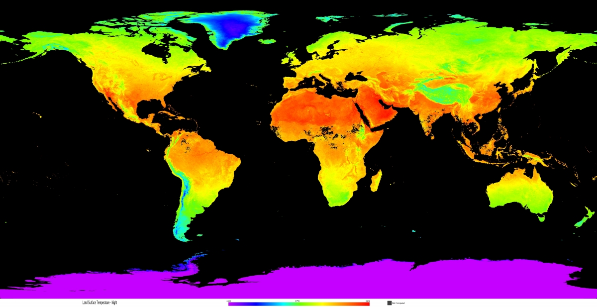
Average temperature of the earth's surface during the night in August 2022, expressed in degrees Kelvin (°C = K - 273.15). The data comes from NASA's MODIS/Terra satellite (MOD11C3 product). Source : USGS Earth data - MOD11C3 v006 - MODIS/Terra Land Surface Temperature/Emissivity Monthly L3 Global.
The demand for data on the Earth's surface and oceans is so great that several space agencies are making great efforts to offer standard products on a regular basis. For example, NASA provides free data coming from MODIS, an instrument aboard the Terra and Aqua satellites. Both satellites observe the entire Earth's surface every 1-2 days. Time series of daily, 8 daily or monthly surface variables are derived from their raw data.
Europe is also doing its bit with the Copernicus Earth observation programme. For instance, the Copernicus Land Service provides a lot of data products on land cover, vegetation indices, soil moisture, surface temperature and so on. The Copernicus Marine Service in turn provides variables on the state of the oceans: sea surface temperature and height, chlorophyll concentration, primary production, etc.
Some examples of area variables and global data products available on a regular basis:
Land Surface Temperature |
The radiation temperature of the land surface.Important variable in the climate system. Helps to evaluate interaction processes between land surface and atmosphere in models and when combined with other variables is a good indicator of the state of the Earth's surface. |
Copernicus Land ServiceNASA MODIS Terra / Aqua(geostationary satellites) |
Leaf Area Index (LAI) |
Green one-sided leaf area per unit area for deciduous forests and half needle area per unit area for coniferous forests.Useful for calculating surface photosynthesis, evapotranspiration and net primary production. With these variables, terrestrial energy, carbon & water cycle processes and bio-geochemical properties of vegetation can be studied. |
Copernicus Land ServiceSentine-3 / Proba-VNASA MODIS Terra / Aqua |
Fraction of Absorbed Photosynthetically Active Radiation (FAPAR)
|
Fraction of photosynthetically-active radiation (400-700 nm) absorbed by vegetation.Same applications as LAI |
Copernicus Land ServiceSentinel-3 / Proba-VNASA MODIS Terra / Aqua |
Terrestrial Evapotranspiration (ET)
|
Refers to processes by which an amount of water moves from the Earth's surface to the atmosphere within a given time period by evaporation (evaporation) and transpiration (via plants).Provides important information for managing water resources. Used for determining regional water and energy balance and soil water status. |
NASA MODIS Terra / Aqua |
Primary Productivity |
Primary production is the amount of carbon biomass produced in a given time period by autotrophic organisms (e.g. plants), mainly through photosynthesis. Part of this is used up for e.g. cell respiration, but the surplus or net primary production (NPP) is used for growth and reproduction and can thus serve as food for other organisms (e.g. herbivores). Data products of primary productivity are used to determine the growth of terrestrial vegetation. |
Copernicus Land ServiceSentinel-3 / Proba-VCopernicus Marine Service - GlobColourSentinel-3 / MODIS / VIIRSNASA MODIS Terra / Aqua |


